

Sunday, August 27, 2023, 1145 PDT Fire Update
Incident Facts:
- Start Date: 8/5/2023
- Cause: Lightning
- Location: 4 miles NE of McKenzie Bridge, Oregon
- Incident#: OR-WIF-230327
- Estimated Containment Date: 9/30/2023
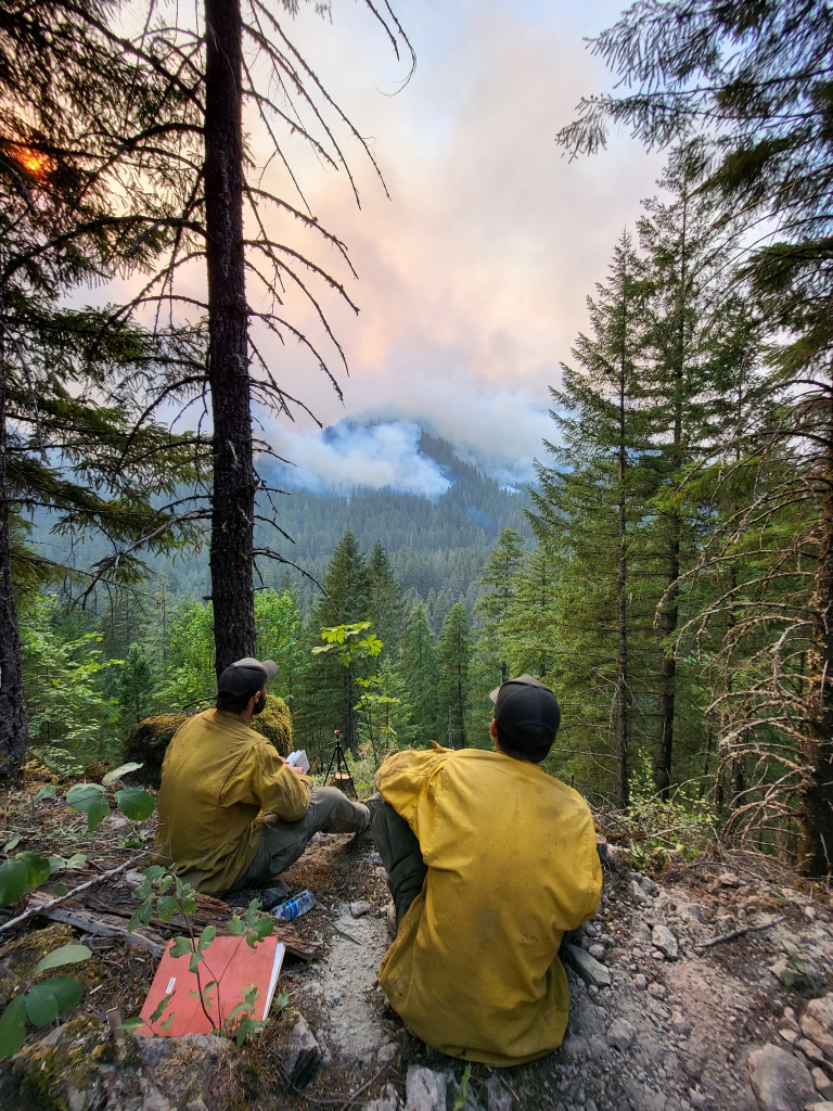
The LOOKOUT FIRE‘s fire behavior is listed today as active with uphill runs, group torching and spotting and still threatening the community, energy, and communication infrastructure while evacuations remain in place.
NEW EVAUCATIONS ALERT!
The following areas are being upgraded to a LEVEL 3 (GO NOW) evacuation notice:
![]() Horse Creek Rd. east of the Horse Creek Bridge.
Horse Creek Rd. east of the Horse Creek Bridge.
![]() Foley Hot Springs
Foley Hot Springs
The following areas are being upgraded to a LEVEL 2 (Be Set) evacuation notice:
![]() Hwy. 242 to the 220 spur
Hwy. 242 to the 220 spur
![]() Yale Ln.
Yale Ln.
![]() Camp Yale Rd.
Camp Yale Rd.
The following areas remain on a LEVEL 3 (GO NOW) evacuation notice:
![]() Mona Campground.
Mona Campground.
![]() Lookout Campground
Lookout Campground
![]() H.J. Andrews Headquarters
H.J. Andrews Headquarters
![]() The area west of Hwy. 126 from Scott Rd. north into Linn County. (Additional evacuations are in Linn County)
The area west of Hwy. 126 from Scott Rd. north into Linn County. (Additional evacuations are in Linn County)
Level 3 (GO NOW) Evacuation Notice: LEAVE IMMEDIATELY. The danger is current or imminent and you should evacuate now. If you choose to ignore this notice, emergency services may not be able to assist you further.
DO NOT DELAY leaving to gather items or protect your home.
THIS WILL BE THE LAST NOTICE YOU RECEIVE.
Entry to evacuated areas may be denied until it is safe.
*Hwy 126 will be remaining open for traffic passing through for the time being.
—
The following areas remain on a LEVEL 2 (Be Set) evacuation notice:
![]() Horse Creek Rd. west and north of Horse Creek Bridge.
Horse Creek Rd. west and north of Horse Creek Bridge.
![]() Hall Rd.
Hall Rd.
![]() Sullivan Ln.
Sullivan Ln.
![]() Alma Dr.
Alma Dr.
![]() Old Foley Ridge Rd.
Old Foley Ridge Rd.
![]() 5600blk of Delta Dr.
5600blk of Delta Dr.
![]() Areas south of McKenzie Hwy. from milepost 50.5 to milepost 54
Areas south of McKenzie Hwy. from milepost 50.5 to milepost 54
![]() Horse Creek Lodge
Horse Creek Lodge
![]() North Bank Rd.
North Bank Rd.
![]() Areas east of the McKenzie Bridge to, and including Drury Ln. north of Hwy. 126, but south of the McKenzie River.
Areas east of the McKenzie Bridge to, and including Drury Ln. north of Hwy. 126, but south of the McKenzie River.
![]() Areas north of Hwy. 126 east of the .5 mile mark on Mill Creek Rd. to the east end of Taylor Rd.
Areas north of Hwy. 126 east of the .5 mile mark on Mill Creek Rd. to the east end of Taylor Rd.
![]() Hwy 126 from the Hwy 242 junction to Scott Rd.
Hwy 126 from the Hwy 242 junction to Scott Rd.
![]() Belknap Hot Springs Rd.
Belknap Hot Springs Rd.
![]() The area east of Hwy. 126 from Scott Rd. north into Linn County. (Additional evacuations are in Linn County)
The area east of Hwy. 126 from Scott Rd. north into Linn County. (Additional evacuations are in Linn County)
![]() Areas north of Hwy. 126 west of the .5 mile mark on Mill Creek Rd. to Blue River
Areas north of Hwy. 126 west of the .5 mile mark on Mill Creek Rd. to Blue River
Reservoir Rd. at the 1501 junction.
![]() The area south of Hwy 126 to the McKenzie River from the east end of McKenzie River Dr. to the McKenzie River Bridge just east of Taylor Rd.
The area south of Hwy 126 to the McKenzie River from the east end of McKenzie River Dr. to the McKenzie River Bridge just east of Taylor Rd.
Residents on a Level 2 (Be Set) evacuation notice who need assistance with large animal sheltering should call Lane County Animal Services at 541-285-8227.
Level 2 means you must prepare to leave at a moment’s notice, and this may be the only notice that you receive. Public safety personnel cannot guarantee they will be able to notify you if conditions rapidly deteriorate.
—
The following areas remain on a LEVEL 1 (Be Ready) evacuation notice:
![]() Areas south of Hwy. 126 from Blue River Reservoir Rd. east to the east end of McKenzie River Dr.
Areas south of Hwy. 126 from Blue River Reservoir Rd. east to the east end of McKenzie River Dr.
![]() The area south of Hwy 126 from the McKenzie River Bridge just east of Taylor Rd. to Scott Creek Rd.
The area south of Hwy 126 from the McKenzie River Bridge just east of Taylor Rd. to Scott Creek Rd.
![]() McKenzie River Dr. and areas directly to the south and east.
McKenzie River Dr. and areas directly to the south and east.
Level 1 means you should be aware of the danger that exists in your area, and monitor local media outlets and telephone devices to receive further information.
*Evacuation notices are also in effect in Linn County related to the Lookout Fire. Visit www.LinnSheriff.org or @LinnSheriff on Facebook for evacuation notices within Linn County.
This is the time for preparation and precautionary movement of persons with special needs, mobile property, pets, and livestock.
An evacuation map is available at www.LaneCounty.org/LookoutFire
Residents are encouraged to sign up for emergency alerts at www.LaneAlerts.org
There have been 19,979 acres burned and there is a 16% containment status reached. About 999 total personnel are still working tirelessly on this fireline along with 19 crews, 53 engines, and seven helicopters.
There have been NO reported structures lost, unlike its fellow Bedrock Fire, which has seen a few.
The CTD is $25 Million.
Photo Credit: USFS/Courtesy: Lookout Fire 2023 Facebook Page
Incident Facts:
- Start Date: 7/22/2023
- Cause: Undetermined
- Incident #: OR-WIF-230266
- Estimated: Containment Date: 10/1/2023
- Fire Fuels: Timber and Brush
- Destroyed: 1 home, 3 minor structures
The BEDROCK FIRE has reported at least four structures lost along with 31,579 acres as being destroyed as the fire continues to see moderate fire behavior with creeping, single tree torching, and smoldering. Structures are still being threatened while evacuations remain in place.
There is a 57% containment achieved as reported today, along with a tally of current resources which include 734 personnel, 13 crews, 39 engines, and 11 helicopters.
According to Fire Officials:
According to Fire Officials: Firefighters, aircrews and helicopters, and heavy equipment from the Bedrock Fire will be heavily engaged with new fires in the area today, including the Horse Creek and Pothole incidents.
Other personnel are being shifted to the more active Lookout Fire. At the same time, hundreds of personnel are still working to finalize containment on the Bedrock Fire. Pacific Northwest Team 2 (PNW2) is now managing all four fires.
“While our main focus has to shift to Lookout and the two new fires, we know we also have to finish the job on Bedrock,” said Jason Loomis, PNW2 Incident Commander.
“Because of the progress that has been made, firefighters will begin removing structure protection equipment currently in place in the Big Fall Creek community. Last night was also the final night shift on the Bedrock Fire and those firefighters are being moved to the Lookout Fire. All containment lines have been held and firefighters continue to patrol the perimeter, taking any actions necessary to keep the perimeter secure.”
PNW2 is working with the Lane County Sheriff to adjust evacuation levels, as necessary, to address changing conditions for both the new and the older, fires in this area. An up-to-date and searchable evacuation map is available through the county’s website: Bedrock Fire Evacuation Areas (https://bit.ly/44rF8Gd). Residents can also call the county at 541-682-2055 for additional information.
CTD: $51.3 Million.

Photo Credit: USFS
(c) 2023 NW Fire Blog
