
UPDATE 2 | 2145 HOURS PT
SUIATTLE RIVER FIRE | Glacier Peak wilderness. Approximately 5 acres, burning on the Darrington Ranger District in Skagit County.

LAKE TOKETIE FIRE | Also burning near the SUIATTLE RIVER FIRE and BOULDER LAKE FIRE (May be also the same as the BOULDER MOUNTAIN FIRE?). Approximately 90 acres.
Source: USDA.gov
UPDATE 1 – 2100 PT
Wildfires and smoke check calls have been very busy today, keeping both local and State fire resources very busy. Here is a recap for Thursday, September 1st as of 2100 hours PT. These are the only ones occurring in Washington State.
“Since July 2020, Stevens County Fire District 1, DNR, and the Stevens County Sheriff’s Office have responded to approximately 20 suspicious fires in the immediate Springdale area. Most have been within close proximity to the schools. Investigations show that there is no plausible cause of most of the fires other than the intentional setting. The Sheriff’s Office does have a specific person(s) of interest in the fires. It is believed that the person(s) responsible live within close proximity to where the fires have been set. Due to the nature of the investigation, further information cannot be released at this time.
Arson is a very difficult crime to prove and often the only evidence is circumstantial. The Stevens County Sheriff’s Office remains committed to catching the suspect(s). We are appealing to the public to remain vigilant and report any suspicious activity. Such activity could be suspicious purchases at local retailers, social media posts, admissions or conversations about the fires, and suspicious activity in the areas the fires have been set. Anyone with any information beyond speculation is encouraged to call the Stevens County Sheriff’s Office.” – Stevens County Sheriff’s Office (WA)
WA-NEC (NE IA Region-DNR)
1930 PT – Smoke Check. MEDICAL LAKE IC. W. Fancher Road, Spokane County. AR7401, AR7404 dispatched. On the scene at 1943 PT. Source: wildCAD.net. Current status: Open incident.
1725 PT – Wildfire. MAPLE CREEK FIRE. Maple Creek. Okanogan County. E21, E22, E692, and Highland 7105 were on the scene at 1842 hours PT. .20 acres burned of grass and shrub. Source: wildCAD.net. Current status: Open incident.
1620 PT – Wildfire. BLACKHAWK FIRE. Cheney, Spokane County. 0.1 acre of timber and understory. Contained at 1710 PT. Controlled at 1910 PT. Source: wildCAD.net. Open incident.
1536 PT – Wildfire. HORSEHOE FIRE. Horseshoe Lake, Pen Oreille. 0.3 acres of timber and litter. Resources arrived on the scene at 1614 PT. Source: wildCAD.net. Open incident.
1322 PT – Wildfire. CORK FIRE. Corkscrew Canyon, Stevens County. 0.3 acres of grass and shrubs. Contained at 1420 PT and controlled at 1700 PT. Source: wildCAD.net Current Status: Open incident, staffed for 9/1/2022.
0538 PT – Wildfire. POWER PEAK FIRE. Power Peak in Pend Oreille County. 5 acres of timber/understory destroyed. C301, E31, LT32, and SRV14 as resources. Current status: Resources still showing assigned, open and active incident.
0436 PT – Wildfire. PINE WEBB FIRE. Springdale in Stevens County. 0.2 acres of timber, litter, and grass. Status: Contained 0530 hours. Controlled at 0630 PT.
WA-CWC (Central WA IA Comm Center)
1800 PT – Wildfire. CRAWFORD OAK FIRE. Horsethief Lake State Park in Klickitat County. 0.25 acres of grass and shrubs. IC: Calkins. Contained at 1900 hours. Controlled at 1958 hours.
1706 PT – Wildfire. COULEE MEDIAN FIRE. Ginko Petrified Forest in Kittitas County. 15 acres of grass and brush. IC: Swell. E4201, E4203, E4204, E6696, KIT25, and KIT27 showing assigned as resources. Fire contained at 2030 hours PT.
1508 PT – Wildfire. SOUTH METHOW FIRE. Hwy 153 in Okanogan County. 0.5 acre. Current status: Open, no resources showing assigned.
0928 PT – Wildfire. BABCOCK DRAW FIRE. Babcock Draw in Grant County. 0.1 acre of grass and shrubs. IC: Kronk. Status: Fire contained and/controlled at 1340 hours PT.
WA-NDC (NW Region-DNR)
1658 PT – Wildfire. PLANTATION FIRE. Unknown location. 0.5 acre of unknown fire fuels. IC: England. Current status: Unknown. No resources showing assigned.
ONGOING WILDFIRE INCIDENTS
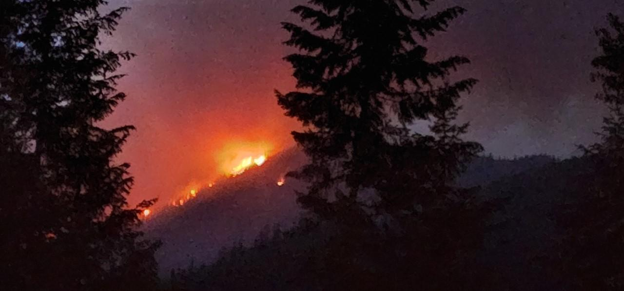
BOULDER MOUNTAIN FIRE – A wildfire started on Wednesday night, August 31st due to lightning which was reported in the Callispel Peak area, prompting Level 3 evacuations and structure protection to go into effect.

Local fire resources Pend Oreille County Fire District #2, WA DNR and the USFS made access to the fire last night around 2140 hours PT and estimated the fire to be at 50 acres, but those reporting to the NIFC (Fire management to the Boise Interagency Fire Center) would observe a higher number of acres destroyed today.
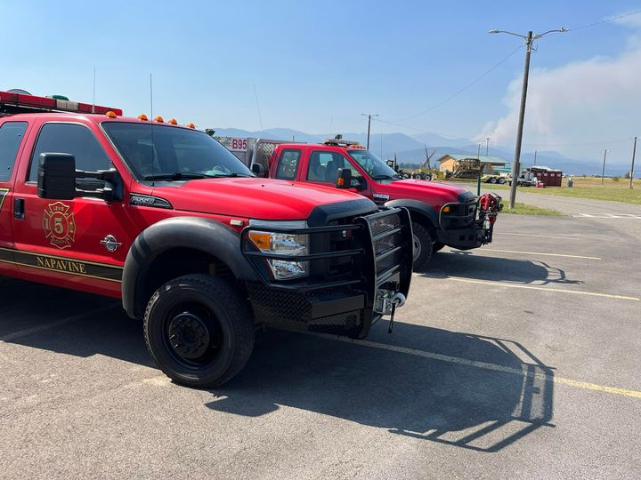
Resources: Lewis County FPD5 deployed their B5-1 which tied in with the Central Strike Team fire response. Current Status: 1,000 acres with a 96% containment status.
It is said to be burning in both Stevens and Pend Oreille Counties. A Type 3 in command of the fire incident.
Pend Oreille County FD2: “The Pend Oreille County Sheriff’s Office and the United States Forest Service have issued a Level 3 Evacuation Order Thursday, September 1, 2022, (GO NOW!) for the Calispel Peak area. The rapidly moving Boulder Mountain Incident Fire have led fire managers to make this decision.
The current evacuation order is for 16 square miles west of milepost 410 on State Route 20. The evacuation area is primarily accessed by Tacoma Creek Road. Tacoma Creek Road is closed above Calicoma Road. The description is:
https://pendoreilleco.org/…/Boulder-Mountain-Fire-Level…
The fire was started by a lightning strike at approximately 5:58 pm on Wednesday, August 31, 2022, and was reported at 30 acres and as of 4:00 pm on Thursday, September 1, 2022, the fire is now at approximately 3,000 acres.
The USFS has Incident Management Teams on scene to manage the fire.
ALL DEBRIS BURNS, PERMIT BURNS, AND CAMPFIRES/RECREATIONAL FIRES ARE BANNED IN PEND OREILLE COUNTY.
BRUSH CREEK 2 FIRE – National Park Service. Being managed as a large fire with a strategy other than full suppression without a Type 1 or 2 IMT being assigned. Current status: 1,000 acres. 96% contained. Four total personnel remain. CTD: $5,000.
WHITE RIVER FIRE – Okanogan-Wenatchee National Forest. 23 miles NW of Leavenworth. Active fire behavior with flanking, backing, and isolated torching. Current size up: 1,289 acres. 1% contained. 341 total personnel with 5 crews, 13 engines, and 5 helicopters. CTD: $10.9 Million.
IRVING PEAK FIRE – Okanogan-Wenatchee NF. 26 miles NW of Leavenworth. Active fire behavior with uphill runs, flanking, and backing. 1,829 acres with 2% containment status. Being managed along with the White River Fire. No resources are showing assigned to this incident. CTD: $2.7 Million.
COPPER LAKE FIRE – North Cascades Park. 36 miles NE of Deming. Agency: National Park Service. Being managed as a large fire with a strategy other than full suppression without a Type 1 or 2 IMT being assigned.
Current Status: Active fire behavior with short crown runs, uphill runs, and short-range spotting. 630 acres with a 0% containment status. 10 total personnel are assigned. CTD: $15,000.
(c) 2022 NW Fire Blog
