

Photo Credit | UC San Diego / ALERTCalifornia (Photo Taken 1/7/2025, 1940 PT)
Sit Rep 1 | Tuesday | January 7, 2025 | 2030 PT
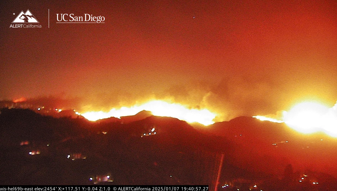
PALISADES FIRE
Incident Summary
The Palisades Fire started this morning at 1030 hours PT from an unknown cause that is under investigation by Fire Officials. It is located southeast of Palisades Drive in Pacific Palisades, California
###
Current Status
Size Up
The Fire has burned through 2,920 acres and has a 0% containment status.
Structure Status
There have been multiple structures lost and several seriously damaged. It will be a while before a damage assessment can be even started as so many communities are being impacted by fire as we are updating you all through this post. At 1500 PT this afternoon, Fire Officials indicated there were 770 acres with structures that were under immediate life and structure threat.
Fire Behavior
Extreme fire behavior, including short and long-range spotting, continues to challenge firefighting efforts for the Palisades Fire. Winds gusts up to 60 MPH are expected to continue through Thursday, potentially aiding in further fire activity and suppression efforts.
Aviation Assets
Due to high winds and danger to aircraft, all aviation assets returned back to their respective bases due to being unable to fly in this weather. This included the helitanker, rotors, and all other aircraft.
A press briefing will be held on Wednesday at 0800 hours at Zuma Beach.
Cause
The cause is unknown and under investigation.
###
Incident Cooperators
CA Gov. Newsom
Unified Command
CAL FIRE San Bernardino-Inyo-Mono Unit, Los Angeles County Fire Department, Los Angeles City Fire Department, and the Los Angeles Police Department.
Incident Management Team
CAL FIRE Incident Management Team II has been activated to assist Los Angeles County Fire and Los Angeles City Fire. Firefighters will continue to work to protect the community, and infrastructures and gain control over fire containment.
###
Evacuation Orders
Immediate threat to life. This is a lawful order to LEAVE NOW. The area is lawfully closed to public access. Some people are refusing to leave as fire resources are being scattered to check on homeowners and residents, and maybe putting their lives in danger. This fire does not care and will burn everything in its path including your home (which can be replaced, you cannot).
Evacuation Orders are in effect for the following zones:
- LOS-Q0767, MAL-C111-A, MAL-C111-B, RMB-U030-A, SSM-U010-A, SSM-U010-B, TOP-U001, TOP-U002, TOP-U003, TOP-U004, TOP-U005, TOP-U006, TOP-U007, TOP-U008, TOP-U009
Evacuation Warnings
Potential threat to life and/or property. Those who require additional time to evacuate, and those with pets and livestock should leave now.
Evacuation Warnings are in effect for the following zones:
- CAL-C405, CAL-C406, CAL-C407, CAL-C408, CAL-C409, CAL-C410, CAL-C411, CAL-C412, CAL-C413, CAL-C414, CAL-C415, DRY-U026, MAL-C111-A, MAL-C112, MTN-U028, RMB-U030-A, RMB-U030-B, RRC-U027, SDP-U029
Evacuation Shelter(s)
Westwood Recreation Center
1350 South Sepulveda Blvd
Los Angeles, CA 90025
###
Road Closures
Follow CHP-West ValleyExternal Link to stay up-to-date on road closures for the Palisades Fire.
- Southbound Pacific Coast Highway at Las Flores Canyon Rd
- Southbound Pacific Coast Highway at Topanga Canyon Boulevard
- Coastline Drive and Southbound Pacific Coast Highway
(c) 2025 NW FIRE BLOG
