

Big Cypress National Preserve | Florida
SUMMARY
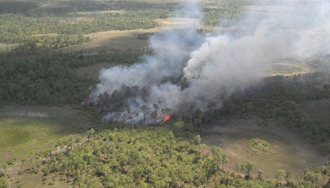
On May 8, 2015, lightning storms passed through the area igniting multiple wildfires located just North and South of I-75 in “Alligator Alley” and 10 miles East of SR29, in the Big Cypress National Preserve. Additional fires have been discovered on May 10th and 12, 2015.
Fires in this Complex are: Ellison, which started on May 8, 2015; Mist, Ellipse, Square, Circle and Triangle were all discovered on May 10, 2015. Dot Fire started on May 12, 2015. Total 4049 acres have burned with a current containment status of 20%. Circle has since consumed Triangle fire and is now known only as Circle Fire.
Due to the remote locations, access has been difficult and Fire Managers have been using primarily Air tankers to drop water over the fires.

- Ellison – 3,143
- Circle – 564
- Ellipse – 214
- Mist – 11
- Square – 116
- Dot – 1
SIT REPS
- May 13, 2015 – 1800 Hours
Temporary closures were announced for the following locations:
Inside and managed by the Big Cypress National Preserve: S of I-5 from milepost 59075 [Turner River Rd]; S to Upper Wagon Wheel Rd; N of I-75 from milepost 59-70; N to the Preserve’s boundary.
Closed to recreational activities, such as ORV, hiking and camping: portions of Florida National Scenic Trail mile 12, N heading towards Northern boundary of the Preserve.
Closures are necessary to protect the public while firefighters and equipment are working in the area.
Mud Lake Complex Fire Info Line: 305-972-6735.

- May 13, 2015 – 1500 Hours
Fire Managers say fire is needed to rejuvenate the ecosystem bringing new life and the reduction of fire fuels but in turn note they must manage it while it is occurring. They are working to limit the forward spread to adjacent to interstate traffic, developed lands, private property and rare and endangered species.
Temps rose with humidity declining and winds have increased.
Resources: 2 crews, 4 swamp buggies, 3 engines, 6 helos, 1 single engine air tanker and air attack. 99 personnel on fire.
Fire is now at 20% with 4049 acres burned.

- May 12, 2015 – 1900 Hours
The fire has now reached a 20% containment status with 3414 acres burned. Moderate weather conditions with some scattered showers. Ellison Fire is at 2515 acres. Circle Fire is at 556 acres. New fire start – “Dot” as of May 12, 2015, at 1300 Hours is at 1 acre is located 4 miles N of MP 66 along I-75.
Resources: 1 Single engine Airtanker, helicopters. 2 Hand crews. 4 swamp buggies. 3 engines, 6 helos. 99 fire personnel.
Fire Plan: To secure NE section of fireline, to limit spreading towards I-75.
- May 12, 2015 – 1100 Hours
Complex Fire is located 30 miles East of Naples, Florida in the Big Cypress National Preserve. Total acres burned are 2077 acres with a 15% containment status. Started by lightning as thunderstorms had passed in the area.
Resources: 1 crew, 4 swamp buggies, 2 engines, 6 helicopters, 1 single engine airtanker, 1 air attack with 73 personnel.

Command for the Ellison, Mist, Ellipse, Square, Circle, Triangle and Dot fires have transitioned from Type 3 Team [Wallace] to Southern Area Red Type 1 Team [Dueitt] as of 0730 Hours on Thursday, May 14, 2015.
- Bureau of Land Management
- Fish & Wildlife Service
- National Park Service
- Florida Dept of Forestry
- Florida Highway Patrol
- US Forest Service
RESOURCES
- Personnel: 99
- Crews: 2
- Swamp Buggies: 4
- Engines: 3
- Helicopters: 6
- Single Engine Airtanker / Air Attack[s]: 1
FIRE FUELS
Southern Rough
WEATHER CONDITIONS
Current conditions are winds from the SE pushing the fire towards I-75. Thunderstorms downdrafts are affecting fire behavior.
A few showers had doused some acres but not enough to completely contain all fires in the Complex.
Higher temps have made the area dry, making one of many concerns for Fire Managers.
ADVISORIES
Traffic: Impacts of low visibility in the area along I-75 may occur due to smoke from the fire. The Police and Fire Departments would like to remind you to drive slow to conditions and remember, to #MoveOver to the right if you see Lights & Sirens – allow emergency vehicles to pass through.
Road Closures: To check for the latest closures, please visit this website for updates –> http://www.nps.gov/bicy/planyourvisit/2015-mud-lake.htm.
[c] 2015 The NW Fire Blog – @nwfireblog / Twitter – The NW Fire Blog / Facebook
