
“There are only two mistakes one can make along the road to truth; not going all the way, and not starting.” –Buddha
* * *
NATIONAL FIRE STATS
176 New Fires [Light] Intiial Activity. 1 Large fire not contained. 5 Contained fires. 95 Uncontained large fires nationally. 2 Area Command Teams. 15 Type 1 IMTs committed. 26 Type 2 IMTs committed.
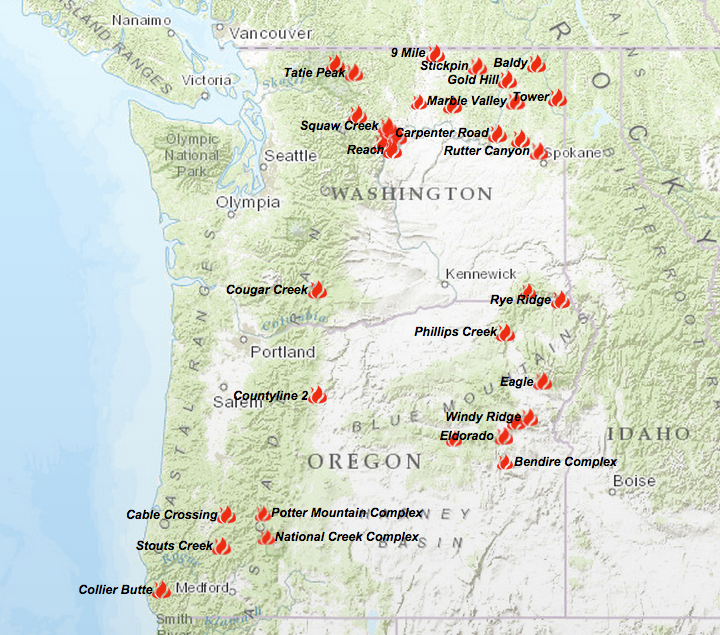
We have separated the fires by areas to make it a little easier to see what’s burning and where in the State of Washington.
* * *
WASHINGTON FIRE STATS
Today’s Fire Stats: 0 new Large fires. 17 new fires for 1 acre. 6 Type 1 IMTs Committed. 10 Type 2 with 1 en route. 3 OSFM. 1 Area Command Team..
* * *
CHELAN
FIRST CREEK FIRE – 8 miles NW of
Start: 8/14/15. Acres: 1726 reduced to 1424 [resized] Containment: Unknown Fire Behavior: Active. Crowing. Short crown runs. Backing. Threatened:
Homes & structures. Evacuations: In effect. Closures: Roads and certain areas. Command: IMT1. PNW Team 2 [Schulte]. Red Cross Evacuation Shelter 1 –> Sterling Middle School, 600 N James Street, E Wenatchee. Shelter 2 –> Entiat Valley Resource Center, 2084 Entiat Way, Entiat.
CHELAN COMPLEX – 10 miles N of
Start: 8/14/15. Cause: Lightning. . Evacuations: In effect. Closures: Roads and certain areas. Command: IMT1. PNW Team 2 [Schulte]
Fire Status: 3 fires [Antoine Creek, Cagle and Reach Fires previously reported individually, merged into this one Complex.] Fire Behavior: Active fire behavior. Uphill runs. Torching. Spotting. Spreading in all different directions to N of Chelan, on both sides of Columbia River. South Flank: Burnouts, dozer lines complete. NW Flank: Structure protection, building dozer lines, working to control spotting. East Flank: Fire slowly spreading E side of Union Valley & NW to Washington Butte. Damage: Some homes, structures and commercial properties destroyed. Threatened: Homes, structures, commercial property, Chelan Airport. Acres: 56,500. Containment: 0%. Resources: WA DNR, State Fire Marshal, WA National Guard. 5 Mobe strike teams for night shift that include 5 Engines each. 6 Helos being used for Water drops, Crew shuttle and Recon. 2 Fixed Wing aircraft for water and/or retardant drops as needed. Antoine Creek Fire. 2313 acres. Cagle Fire. 47,342 acres. Reach Fire. 6845 acres.
MCFARLAND CREEK – 18 miles N of Chelan, 8 miles of Pateros
Previously reported as “Squaw Creek”
Start: 8/14/15 on Friday. Cause: Unknown. Comments: Previously reported as Squaw Creek, this fire is being managed by an IMT/PNW Team 2 . Fire Status: Active fire behavior with flanking, group torching and spotting. Acres: 384. Containment: 0%. Closures: Roads and trails. Conditions: Steep terrain. Fire Suppression Tactics: Indirect and Direct fire suppression.

COLVILLE
GOLD HILL FIRE – 10 miles W of
Start: Unknown. Cause: Lightning. Acres: 700. Fire Behavior: Moderate. Group torching. Containment: 0%.
FERRY COUNTY
KETTLE COMPLEX – Northern Ferry County
Fire Summary: Resources: 400. Total Acres: 36,950.
Stickpin Fire. 26 miles NW of Colville. Start: 8/11/15. Cause: Lightning. Geographical Location: Between Profanity Peak and Ryan Hill. Ranger District: National Forest: Colville NF. County: Ferry. Acres: 35,530. State Mobe: 8/15/15. Resources. Crews: 6. Engines: 24. Dozers: 6. Water Tenders: 15. Helicopters: 0, but on stand-by. Personnel: 400.. Injuries: 0. Damages: 0 homes. Containment: 0%.
[ NEW ! ] Graves Mtn Fire. Hwy 20/ Sherman Pass. Start: 8/13/15. Cause: Tree falling into power lines after thunderstorm in area. Acres: 1300. National Forest: Colville. Shelter: Red Cross Shelter at Republic School.
[ NEW! ] Roy Rd Fire. W of Republic. Start: Unknown. Cause: Unknown Acres: 120. Limited Info.
GLENWOOD
COUGAR CREEK FIRE – 6 miles NW of

Start: 8/10/15. Cause: Lightning. Land Protected: by Yakama Indian Nation, DNR and the USFS. Acres: 22,500. Fire Status: Active fire behavior. Group torching. Containment: 15%. ROS: None. Resources. Personnel: 452. Helicopters: 6. Water Tenders: 11. Crews: 14. Engines: 15. Dozers: 9. Other: 1. Command: IMT2. WA Team5 [Leitch]. Evacuations: Level 1 notices for residents N of Glenwood.
LUCERNE
WOLVERINE FIRE – 3 miles NW of
Start: 6/29/15, around 0730 hours. Cause: Ranger District: Chelan. Command: PNW IMT2. [Also, managing Reach Fires, First Creek Fire, Black Canyon Fire, McFarland Creek and Wolverine Fire] Acres: Containment:
NEWHALEM
THURSDAY CREEK – 13 miles NW of
The Thursday Creek is located 13 miles NE of Newhalem that started on 8/10/15 by lightning. It is currently at 200 acres with a 0% containment status. Active fire behavior reported.
OMAK
LIME BELT FIRE – 13 miles NW of
Lightning started this fire located 13 miles NW of Omak, which has scorched 2560 acres. Reports the fire is has an active fire behavior with single torching, running and short-range spotting.
NORTH STAR FIRE – 25 miles E of
Start: 8/13/15. Cause: Human. Acres: 25,000. Geographical Area: Colville Indian Reservation. Personnel: 83. Evacuations: In effect. [see info on inciweb http://inciweb.nwcg.gov/incident/4524/.%5D

PATEROS
BLACK CANYON FIRE – 8 miles W of
Start: 8/14/15 @ 1145 hours. Cause: Lightning. Conditions: Steep terrain. Acres: 3449. Containment: 0%. Fire Status: Active Fire behavior. Flanking. Group torching. Spotting: Closures: Road and trails. Command: IMT1. PNW Team 2 [Schulte]. NOTICE –> Community Meeting, Tuesday, 8/18/15 at the Pateros Fire Station at 1900 Hours. Update of Black Canyon and McFarland Fires on Agenda. Part of the Okanogan Complex / to be updated Tuesday PM
KNOBBY FIRE – 50 miles NW of
Located 50 miles NW of Spokane, this incident started on Saturday, 8/15/15. In monitor status. The fire is only at 150 acres and has a 0% containment status. Cause is unknown. Limited info being reported. Part of the Okanogan Complex Fire / to be updated 8/18/15 Tuesday.
WINTHROP
BEAVER LAKE FIRE – 15 miles E of
This fire is located 15 miles E of Winthrop which started on Friday, 8/14/15 with an unknown cause. ICT3 team is in command. They are reporting 800 acres with a 0% containment status. Active fire behavior with running and single tree torching. Part of the Okanogan Complex / to be updated 8/18/15.
OKANOGAN COMPLEX- 50 miles NW of
The Okanogan Complex is located 50 miles NW of Winthrop that was started by lightning, has reached 2,000 acres with a 0% containment status. It is reported to have active fire behavior, threatening residences. Road and area closures are in effect. FMAG approved on 8/15. To be updated 8/18/15.
Additional Fires:
Due to time constraint, we were unable to add the following: Tower Fire, Carpenter Rd, Lime Belt, Beaver Lake and Marple Valley. Any new ones will be added to our Tuesday post.
* * *
A HUGE Thank You –> Thank you to the many fire crews, firefighters, pilots, Fire Managers, Support personnel, Red Cross shelter volunteers and the vast amount of others we probably have unintentionally forgotten to mention & thank for all of your hard work, dedication, commitment and tireless efforts. You all are so awesome and we can’t thank you enough for what you all are doing or have done out there on the many fire incidents.
Thank You —> To our many followers, those who have provided great tips and engaging us with questions, concerns or corrections. We appreciate every single one of you all. We wish you all a Safe and Sane day/night wherever your travels/shifts may take you.
[c] 2015 The NW Fire Blog
