
ALASKA QUAKE 2020
UPDATE 1
The USGS reported a M7.8 earthquake that rattled the State of Alaska which prompted an emergency Tsunami alert.
Giving you a little prespective – Courtesy of NWS Tsunami Alerts
The earthquake is approximately 99 km (61.51 miles) SSE of Perryville, Alaska (USA) that occurred 06:12:42 (UTC) on 7/22/2020 or around 2312 PT on 7/21/2020 (West Coast time). It would have been around 2212 AKDT.
Quake has been deemed to have been a M7.8 that is located Lat: 55.2* N. Lon: 158.6* W. It is approximately 75 miles south of Chignik, Alaska that was 8 miles in depth.
== TSUNAMI ALERT ==
A Tsunami Alert has been issued by NOAA.
ALERT #2

...A TSUNAMI ADVISORY IS NOW IN EFFECT...

Tsunami Warning in Effect for;

 * SOUTH ALASKA AND THE ALASKA PENINSULA, Pacific coasts from
   Kennedy Entrance, Alaska (40 miles SW of Homer) to Unimak
   Pass, Alaska (80 miles NE of Unalaska)

 * ALEUTIAN ISLANDS, Unimak Pass, Alaska (80 miles NE of
   Unalaska) to Samalga Pass, Alaska (30 miles SW of Nikolski)

Tsunami Advisory in Effect for;

 * SOUTH ALASKA AND THE ALASKA PENINSULA, Pacific coasts from
   Cape Suckling, Alaska (75 miles SE of Cordova) to Kennedy
   Entrance, Alaska (40 miles SW of Homer)

 * ALEUTIAN ISLANDS, Samalga Pass, Alaska (30 miles SW of
   Nikolski) to Amchitka Pass, Alaska (125 miles W of Adak)
   including the Pribilof Islands

For other US and Canadian Pacific coasts in North America,
the level of tsunami danger is being evaluated.  Further
information will be provided in supplementary messages.

PRELIMINARY EARTHQUAKE PARAMETERS - UPDATED
-------------------------------------------

 * The following parameters are based on a rapid preliminary
   assessment of the earthquake and changes may occur.

 * Magnitude      7.8
 * Origin Time    2213 AKDT Jul 21 2020
                  2313  PDT Jul 21 2020
                  0613  UTC Jul 22 2020
 * Coordinates    55.2 North 158.6 West
 * Depth          8 miles
 * Location       75 miles S of Chignik, Alaska
                  520 miles SW of Anchorage, Alaska

FORECASTS OF TSUNAMI ACTIVITY
-----------------------------
 * Tsunami activity is forecasted to start at the following
   locations at the specified times.

                 FORECAST
                 START
SITE             OF TSUNAMI
----             ----------

 * Alaska
Sand Point       2315 AKDT Jul 21
Unalaska         2350 AKDT Jul 21
Kodiak           0005 AKDT Jul 22
Cold Bay         0015 AKDT Jul 22
Adak             0015 AKDT Jul 22
Seward           0030 AKDT Jul 22
Valdez           0050 AKDT Jul 22
Cordova          0100 AKDT Jul 22
Saint Paul       0115 AKDT Jul 22
Homer            0125 AKDT Jul 22

OBSERVATIONS OF TSUNAMI ACTIVITY
--------------------------------
 * No tsunami observations are available to report.
ALERT #1
FORECASTS OF TSUNAMI ACTIVITY
-----------------------------
 * Tsunami activity is forecasted to start at the following
   locations at the specified times.

                 FORECAST
                 START
SITE             OF TSUNAMI
----             ----------

 * Alaska
Sand Point       2315 AKDT Jul 21
Kodiak           0005 AKDT Jul 22
Cold Bay         0015 AKDT Jul 22

OBSERVATIONS OF TSUNAMI ACTIVITY
--------------------------------
 * No tsunami observations are available to report.

RECOMMENDED ACTIONS
-------------------
Actions to protect human life and property will
vary within tsunami warning areas.

If you are in a tsunami warning area;

 * Evacuate inland or to higher ground above and beyond
   designated tsunami hazard zones or move to an upper floor
   of a multi-story building depending on your situation.

 * Move out of the water, off the beach, and away from
   harbors, marinas, breakwaters, bays and inlets.

 * Be alert to and follow instructions from your local
   emergency officials because they may have more detailed or
   specific information for your location.

 * If you feel a strong earthquake or extended ground rolling
   take immediate protective actions such as moving inland
   and/or uphill preferably by foot.

 * Boat operators,
     * Where time and conditions permit, move your boat out to
       sea to a depth of at least 180 feet.

     * If at sea avoid entering shallow water, harbors,
       marinas, bays, and inlets to avoid floating and
       submerged debris and strong currents.

 * Do not go to the shore to observe the tsunami.

 * Do not return to the coast until local emergency officials
   indicate it is safe to do so.

IMPACTS
-------
Impacts will vary at different locations in the warning
areas.

If you are in a tsunami warning area;

 * A tsunami with damaging waves and powerful currents is
   possible.

 * Repeated coastal flooding is possible as waves arrive
   onshore, move inland, and drain back into the ocean.

 * Strong and unusual waves, currents and inland flooding
   can drown or injure people and weaken or destroy structures
   on land and in water.

 * Water filled with floating or submerged debris that can
   injure or kill people and weaken or destroy buildings and
   bridges is possible.

 * Strong and unusual currents and waves in harbors,
   marinas, bays, and inlets may be especially
   destructive.

 * Some impacts may continue for many hours to days after
   arrival of the first wave.

 * The first wave may not be the largest so later waves may
   be larger.

 * Each wave may last 5 to 45 minutes as a wave encroaches
   and recedes.

 * Coasts facing all directions are threatened because the
   waves can wrap around islands and headlands and into bays.

 * Strong shaking or rolling of the ground indicates an
   earthquake has occurred and a tsunami may be imminent.

 * A rapidly receding or receded shoreline, unusual waves and
   sounds, and strong currents are signs of a tsunami.

 * The tsunami may appear as water moving rapidly out to sea,
   a gentle rising tide like flood with no breaking wave,
   as a series of breaking waves, or a frothy wall of water.
RECENT QUAKE HISTORY
July 22, 2020
M5.7 – 123km SE of Sand Point, Alaska. 7/22/2020 0620 UTC. (0026 PT) 26.2 km depth.
July 21, 2020
M7.8 – Alaska Peninsula. 105 km SSE of Perryville, Alaska. 28.0 km in depth. 2329 PT / 7/22/2020 0612 UTC. Tsunami alert issued for Alaska.
July 7, 2020
M5.9 – Kodiak Island Region, Alaska – USGS
July 5, 2020
M5.5 – South of Alaska – USGS
ALASKA’S ANNUAL QUAKE HISTORY
2018
November 30, 2018
Quake hits the Anchorage area and causes a lot of serious damage to infrastructure, homes and emotional scarring in people’s lives.
3 aftershocks occur:
- M5.1 – 11/30/2018 – 2207 AKDT – 17 miles south of Willow
- M5.3 – 11/30/2018 – 2207 AKDT – 19 miles west of Anchorage
- M4.5 – 11/30/2018 – 2207 AKDT – 14 miles nw of Elmendorf
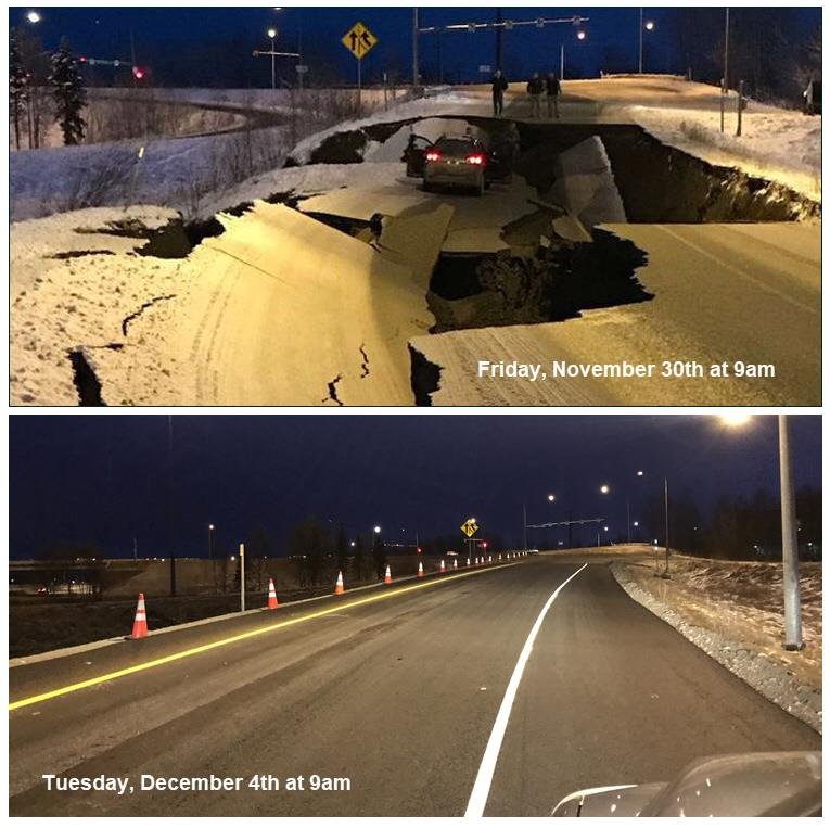
Damaged roadways on November 30th show what it looked like and how quick repairs were made – only taking 4 days. – Credit | AK DOT
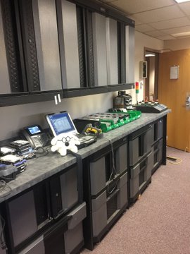
“Mother Nature’s horrible dance moves threw stuff all over the place in our APD Help Desk / IT Center, among many other places. Here’s a look at it on Friday vs. the following Monday.” – Anchorage PD

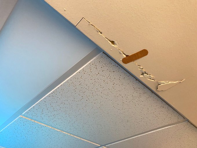
“After the earthquake, we found some structural damage in the ceiling of our APD Dispatch Center. Looks like someone up there already assessed the damage and took care of it. As you can see, they had all the necessary tools.” – Anchorage PD
2017
July 17, 2017
M7.7 shakes near the western tip of the Aleutian Islands, Alaska with a 10km depth. Hazardous tsunmai alert issued as a possibility. It is said to have released more energy than all Lower 48 earthquakes since 1992 combined.
2016
January 24, 2016
A M7.1 hits west of Iliamna (Southern), Alaska. No threat of tsunami is given.
April 2, 2016
A M6.2 rattles a remote region of southeastern Alaska.
2015
In the year of 2015, the State was rocked by 1,575 earthquakes compared to its counterparts California at 130 and Oklahoma at 888.
July 26, 2015
M6.9 hits near the Aleutian Islands. No tsunami alerts for the West Coast issued.
2014
In 2014, there were 1,296 quakes compared to 191 in California and 585 in Oklahoma.
May 4, 2014
M4.5 quake rattles the area.
2013
2013 Presented Alaska with 1,329 quakes with California at 240 and Oklahoma at 103 up from the year before.
January 5, 2013
M7.5 is approximately 106km southwest of Craig, Alaska.
2012
September 26, 2012
M6.9.
2011
September 9, 2011
M4.3. Quake hits the Rat Islands, Aleutian Islands in Alaska.
PUBLIC SERVICE ANNOUNCEMENT
Be ready for more earthquakes
- More earthquakes than usual (called aftershocks) will continue to occur near the mainshock.
- When there are more earthquakes, the chance of a large earthquake is greater which means that the chance of damage is greater.
- The USGS advises everyone to be aware of the possibility of aftershocks, especially when in or around vulnerable structures such as unreinforced masonry buildings.
- This earthquake could be part of a sequence. An earthquake sequence may have larger and potentially damaging earthquakes in the future, so remember to: Drop, Cover, and Hold on.
What we think will happen next
According to our forecast, over the next 1 Week there is a 4 % chance of one or more aftershocks that are larger than magnitude 7.8. It is likely that there will be smaller earthquakes over the next 1 Week, with 140 to 13,000 magnitude 3 or higher aftershocks. Magnitude 3 and above are large enough to be felt near the epicenter. The number of aftershocks will drop off over time, but a large aftershock can increase the numbers again, temporarily.
More details about the earthquake forecast are provided in the section “Our detailed aftershock forecast” below.
About this earthquake and related aftershocks
So far in this sequence there have been 2 magnitude 3 or higher earthquakes, which are strong enough to be felt, and 0 magnitude 5 or higher earthquakes, which are large enough to do damage.
Our detailed aftershock forecast
The USGS estimates the chance of more aftershocks as follows: Within the next 1 Week until 2020-07-29 07:10:00 (UTC):
- The chance of an earthquake of magnitude 3 or higher is > 99 %, and it is most likely that as few as 140 or as many as 13,000 such earthquakes may occur in the case that the sequence is re-invigorated by a larger aftershock.
- The chance of an earthquake of magnitude 5 or higher is 98 %, and it is most likely that as few as 0 or as many as 130 such earthquakes may occur.
- The chance of an earthquake of magnitude 6 or higher is 68 %, and it is most likely that as few as 0 or as many as 14 such earthquakes may occur.
- The chance of an earthquake of magnitude 7 or higher is 18 %, and it is most likely that as few as 0 or as many as 3 such earthquakes may occur.
About our earthquake forecasts
No one can predict the exact time or place of any earthquake, including aftershocks. Our earthquake forecasts give us an understanding of the chances of having more earthquakes within a given time period in the affected area. We calculate this earthquake forecast using a statistical analysis based on past earthquakes.
Our forecast changes as time passes due to decline in the frequency of aftershocks, larger aftershocks that may trigger further earthquakes, and changes in forecast modeling based on the data collected for this earthquake sequence.
This forecast was issued: 2020-07-22 07:02:42 (UTC)
This forecast will be updated on or before 2020-07-29 07:02:42 (UTC) – USGS
(c) 2020 NW Fire Blog – Updated 7/22/2020 0125 PT
