
Published August 5, 2022, Friday, 1945 hours PT
====== INCIDENT SUMMARY ======
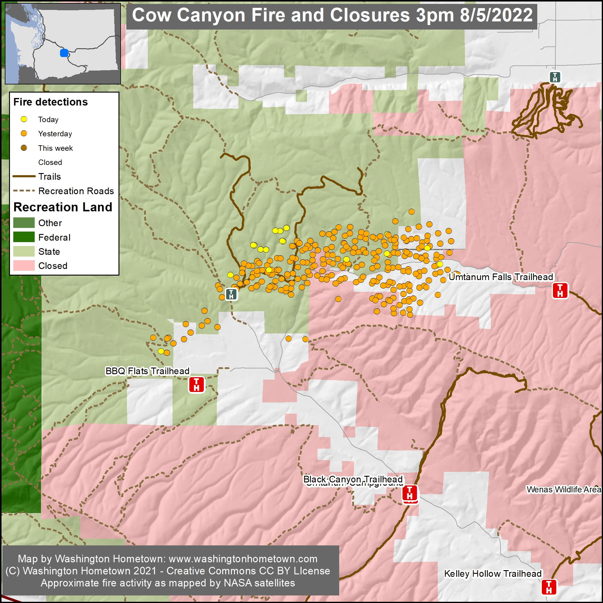
The COW CANYON FIRE is located about 8-11 miles north of Naches and through the Manastash border of Yakima and Kittitas Counties.
A TFR is in effect, meaning all aircraft, including drones should not be flying over the fireline for any reason unless it’s the Official aircraft for police and fire. If you fly, they can’t.
====== CLOSURES ======
The WDFW has closed the Wenas Wildlife Area because of the fire.
====== CURRENT STATUS ======
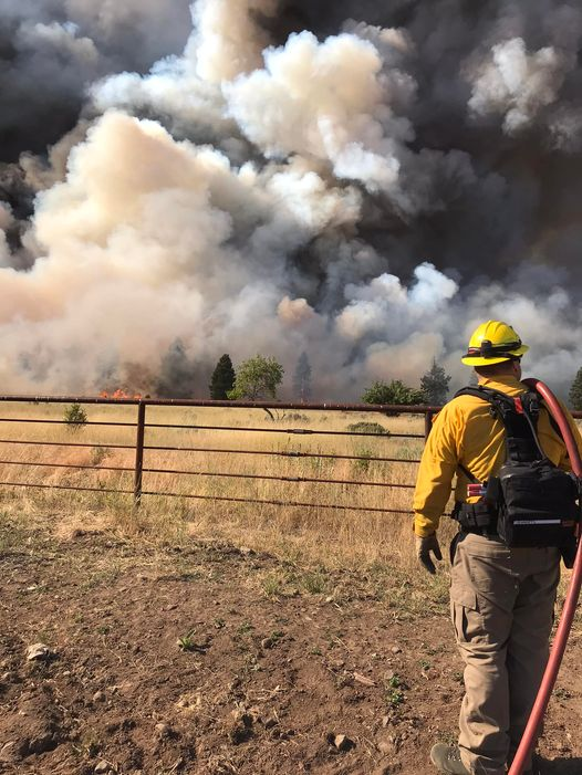
FIRE BEHAVIOR
Fire behavior is active with uphill runs, wind-driven runs, and, running.
SIZE UP
About 5,600 acres of timber and grass have been consumed.
There is a 0% containment status at this time.
====== RESOURCES ======
EVACUATIONS
Evacuations are in effect. Please visit these links for evacuation orders in Kittitas and Yakima Counties: Level 2 and 3 evacuations are in place on the Cow Canyon Fire in both Yakima and Kittitas Counties. Evacuation details for Yakima County are located at https://www.facebook.com/YakimaCountyOEM and Kittitas County is at https://tinyurl.com/2225ruhs.
EMERGENCY ALERTS
COMMUNITY MEETING
- Virtual Community Meeting
- Vantage Highway and Cow Canyon Fires
- Saturday, August 6 at 5 PM
- Live on the Central Washington Fire Information Facebook Page
- https://www.facebook.com/cwafireinfo
Firefighters will have fire updates and answer questions from the public on the Central Washington Fire Information Facebook page. We will monitor for questions live but encourage questions to be asked ahead of time to ensure the information is readily available. Please submit your questions to the Central Washington Fire Information Facebook page or the respective incident email: Vantage Highway fire 2022.vantagehighway@firenet.gov or Cow Canyon Fire 2022.cowcanyon@firenet.gov
FIRE WEBCAM
ALERT Wildfire – Elephant camera view –> https://www.alertwildfire.org/region/oregon/?camera=Axis-Elephant&fbclid=IwAR3xAUpuR6U4YVSJXVAwLH8Ehs-Y5CKwIsq-mX3gUc_eh8FJvG-HckXzjD8
====== FIRE RESPONSE / INCIDENT COOPERATORS ======
FIRE COMMAND
This incident is said to be managed without a Type 1 or 2 IMT assigned (according to the NIFC) but according to the Kittitas County Sheriff’s Office, the NWIMT 12 assumed command this morning at 0600 hours. They are also managing the VANTAGE HWY FIRE. (we will still cover them as separate fire posts).
STATE MOBE RESPONSE
There is a total of 300 fire personnel along with six hand crews, six engines, five dozers, six water tenders, and one copter some resources are being shared with the nearby VANTAGE HWY FIRE incident (aircraft).
The Lead Agency is WA DNR.
This is a State Mobe staffed incident with resources being deployed as mutual aid/incident cooperators from as far away as Skagit County (Burlington), Washington, and all over the State.
Incident Command is being managed by Jeff Dimke and Bobby Shindelar.
INCIDENT COOPERATORS
BURLINGTON FIRE DEPARTMENT – The Department is deploying one fireline Medic and will be arriving at the incident on Saturday.
INCIWEB – Providing fire pressers.
YAKIMA VALLEY EMERGENCY MANAGEMENT – Posting evacuation information on their Facebook page: https://www.facebook.com/search/top?q=cow%20canyon%20fire%20.
KITTITAS COUNTY SHERIFF’S OFFICE
YAKIMA COUNTY SHERIFF’S OFFICE
YAKIMA COUNTY FIRE DISTRICT #5
NACHES FIRE DEPARTMENT
SE WA IMT
CENTRAL WA FIRE INFO
NORTHWEST COORDINATION CENTER
SELAH FIRE DEPARTMENT – Has had many members assisting as State Mobe resources on Wednesday and Thursday.
WASHINGTON HOMETOWN – assisting us with mapping support for various fire incidents, including this one. All maps and photos are being used with written permission from the organization.
====== DAMAGE ASSESSMENTS ======
STRUCTURES LOST
Four structures have been burned.
COST-TO-DATE
The cost-to-date for fire suppression and containment efforts has reached $200,000.
====== SOCIAL MEDIA ======
(c) 2022 NW Fire Blog
