
9/1/2022 THURSDAY, 2030 HOURS PT
The ROUTE FIRE is still active and spreading while burning up to 5,208 acres as of last night. About 100 acres have been impacted by the fire on U.S. Forest lands.
About 512 total personnel are assigned along with 58 engines, 11 hand crews, 10 dozers, five water tenders, eight copters, two fixed-wing aircraft, and others from CAL FIRE, CHP, Co of Los Angeles Parks and Rec, Red Cross California, and Southern CA Edison.
550 structures are still under threat with two of them being destroyed. None have been damaged. All evacuation orders have been lifted.
However, fire resources and equipment have been able to obtain a 27% containment status, which is great news for this out-of-control firestorm.
LA County Emergency Mapping and Information website: https://lacounty.gov/emergency/
Evacuations still in place:
- North of North Lake Hills Elementary School
- South of Templin Highway (includes Paradise Ranch Mobile Estates)
- East of I-5 Freeway
- West of Castaic Lagoon
Evacuation Shelter Location:
Frazier Mountain High School
700 Falcon Way
Lebec, CA 93243
Small animals can be evacuated to:
Castaic Animal Shelter
31044 North Charlie Canyon Road
Castaic, CA 91384
To stay up-to-date on evacuations, visit: https://twitter.com/SCVSHERIFF
Lead Fire Agency: Los Angeles FD PIO and in Unified Command with LA City FD and Angeles National Forest. Other agencies assisting as mutual aid include CAL FIRE.
8/31/2022 WEDNESDAY
21:30 PT – UPDATE 7

The ROUTE FIRE is now listed as a 4,625 acre fire with a 0% containment status, according to those reporting to Inciweb’s website.
Evacuations still in place:
- South of Templin Highway (includes Paradise Ranch Mobile Estates)
- East of I-5 Hwy
- West of Castaic Lagoon
Evacuation Shelter: Frazier Mountain High School, 700 Falcon Way, Lebec, CA 93243.
Small Animals Shelter: Castaic Animal Shelter, 31044 N Charlie Canyon Road, Castaic, CA 91384.
Evacuation Updates: https://twitter.com/SCVSHERIFF
Road Closures: I-5 Highway is closed in both directions, NB at Lake Hughes Road and SB at Vista Del Lago.
Traffic Updates: visit: https://twitter.com/CaltransDist7
Incident Cooperators: Red Cross Central California, CAL FIRE, LA CO and CITY FD, Caltrans District 7.
Eight (8) firefighters have now sustained heat-related injuries.
Aviation aircraft for night ops include OCFA Fire Watch 76, and Helitanker 47. LACoFD Copter 21, Helitanker 55. VCFD Helitanker 61 is enroute.
17:30 PT – UPDATE 6
There have now been seven firefighter injuries due to being related to the heat.
Current weather conditions are 100*F temps with sunny skies and relative humidity of 17%. Winds are blowing at 21 mph and there is no precipitation in the air. The high for today was forecasted at 110*F and on Thursday, it is to be up to 109*. Friday, temps will dip down to a toasty 103*F but for the rest of the weekend and into next week, temps are to remain the same for the area of Castaic.
CLOSED: Ridge Route on both sides just south of Templin. (CHP).
Just before 17:00 PT this evening, the IC called for the immediate need for five Type 3 strike teams recommended for the planning side of operations. There is no divert status still in place for all air tankers.
16:12 PT – UPDATE 5
The Santa Clarita Valley Sheriff’s Station with the Los Angeles County Sheriff has issued MANDATORY EVACUATIONS for residents in the Paradise Mobile Estates and all structures south of Templin Highway along Upper Ridge Route Road. MUST EVACUATE TO THE NORTH.
Fire has scorched 250 acres of heavy fire fuels.
16:10 PT – UPDATE 4
Fire spotted across Grasshopper Canyon about 34 minutes ago which is increasing the acreage to around 160+ acres.

Fire behavior is now being reported as extreme and it is creating its own weather patterns which create very dangerous fire conditions in the sky and on the ground.
16:00 PT – UPDATE 3
Evacuation orders have been issued for those on Old Ridge Route on the north end.
At 1530 hours PT, the IC requested to have four additional hand crews and a replacement of the VLAT for which this one was diverted to another fire burning the San Diego County area.
A warning was issued to firefighters on the ground of the possibility of the smoke plume collapsing.
What does this mean for firefighters? According to Wikipedia, one of our go-to places for a plethora of fire knowledge says this in simple terms, “Once that column hits cooler air in the atmosphere, it can change direction and then the column can collapse. The downward rush of air from a collapsing column can change the direction of the winds on the ground and create hazardous conditions.”
Aircraft assigned (mutual aid): Air Attack 12, Lead47. T73, T74, T75, T78, T107, T914. LACoFD Copters 14, 16, Helitanker 55. OCFA Helitanker 47, Fire Watch 76. VCFD Helitanker 61. Helitanker 1HT.
15:40 PT – UPDATE 2

A request for Helitankers 47 and 61 from Ventura and Orange County is on order. The ridge structure defense structure group has been established. As of 15:18PT, the fire has consumed about 162 acres of heavy fire brush and was escalated to a 3-alarm fire at 1332 hours.
The Fire Department reported one patient being transported to a nearby hospital with unknown injuries. Two firefighters were previously taken to the nearest hospital with minor heat-related injuries.
No structures were reported as being threatened or evacuated at the time of this update.
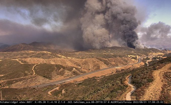
Fire Pics: ALERTCalifornia’s fire cam shows the large column of smoke to the right of the photo image, while ground resources aggressively engage on a hillside which shows the conditions fierce and very steep.
Aviation assets assigned are AA51, Tankers 103, 107, and 131, LA Co FD Copters 14, 16, and Helitanker 55. Two additional tankers are on order.
Fire watchers have observed a small pyrocumulus cloud over the fire area.
FIRE FACT
A pyrocumulus cloud forms from rising air that results from intense heating of the surface by phenomena such as wildfires or volcanic eruptions.
The fires that generate these clouds can be man-made or natural. A big fire produces strong upward-moving air currents that carry water vapor and ash upward.
Source: Wikipedia
The smoke column can be as far as the City of Los Angeles and in Burbank, California as it stretches high in the sky and beyond.

12:11 PT – UPDATE 1
The ROUTE FIRE is located along NB I-5, north of Lake Hughes Road (Los Angeles County), north of Castaic, California.
The brush fire which started on Wednesday, August 31, 2022, prompted an emergency public alert via the Pulsepoint app at 12:09PT today. Local resources were dispatched at 12:01PT.
Reported originally as a five-acre brush, running uphill in light flashy fuels.

Resources from Angeles National Forest, Los Angeles County FD, Los Angeles City FD, SCVand CHP – Santa Clarita Valley Sheriff’s Station are assisting with equipment and personnel.
Units include from LA County Fire Department’s BC22, BC6,CC91, COPT14, COPT16, HTNK55, LFDCOPT, P77, SU16, SU20, SUP, CC122, CC123, CC161, CC162, CN16, DZ9, E124, E126, E143, E149, E156, E477, E76, P76, S149 TRAN1 and WT156.
12:26PT — CHP is closing the two lanes of NB 5Fwy before the Lake Huges Road exit.
1235 PT — 2nd alarm resources E111, E108, 150, 123, 81, 78, 74, Dozer team, Task Force 4, and Trucks 28, 128, and 283 were dispatched. Several other units were put on move-ups to these stations on a Code 3 response.

There are no evacuation orders in effect at this time but as the fire behavior increases and continues to spread to area with heavy fire fuels, this could be a possibility and we will provide updates and resources.
LA County Fire Ops Copters is assisting with water-dropping helicopters along with LA County and City FDs, Angeles National Forest, and CAL FIRE.
1305 PT — Another deployment of resources was dispatched to include Engines 3, 4, 27, 45, and 118, along with Battalion 3 Charlie and Strike Team 1103, to respond to Fire Station 126.
The fire has now burned approximately 60 acres and the fire behavior is very active.
The Fire Department PIO says there are no structures currently threatened at this time.
(c) 2022 NW Fire Blog
