

Incident: Moose Meadow Wildfire

or Immediate Release Fire Information: (406) 859-6005
July 30, 2013 8 p.m. Office hours: 7 a.m. to 9 p.m.
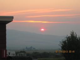
Incident: Wildland fire, lightning-caused, reported on July 25, 2013.
Location: 18 miles southeast of Philipsburg, MT and 15 miles west of Georgetown Lake, MT
Jurisdiction: Beaverhead-Deerlodge National Forest
Cooperating Agencies: Other cooperating entities include the Philipsburg Volunteer Fire Department, Montana DNRC, American Red Cross, Granite County Sheriff and DES.
Incident Commander: Shawn Pearson, Northern Rockies Type II Incident Management Team (IMT).
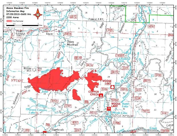
Current Size: 3,000 acres Containment: 10%
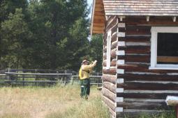
Strategy: Full Suppression Structures Threatened: 30 Structures Lost: 0 Structure Protection:Implemented
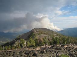
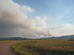
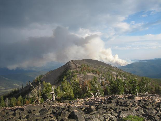
Today’s Activity: Slightly cooler temperatures aided by cloud cover allowed crews to increase containment to 10%. Aircraft continued to provide support with water and retardant drops plus logistical support for spike camps. The structure protection group continued installing hose lays and sprinklers near structures threatened by the fire. Crews and helicopters are working closely to keep the fire west of Roads 5106 and 80 and east of Road 5107.
Current Resources: The number of firefighters on the incident is 488. Resources assigned nclude fourteen crews, five helicopters, fifteen engines, three w
aterter tenders, two dozers, four skidgines,four feller bunchers, and support personnel.
Planned Actions: The weather forecast for Wednesday calls for increased cloud cover as some moist fronts move through the area. These fronts are expected to bring unstable air, minimal moisture, possibility of lightning, and gusts of wind up to 45 mph. These weather conditions could slow firefighters’ progress. Crews will continue fireline construction along the northwest and southwest flanks. while aircraft continues its aerial assault. Structure protection will patrol for spot fires along Roads 5106 and 80.
Special Messages/Closures: The Evacuation Order issued on July 28th by the Granite County Sheriff is still in effect. The Evacuation Order affects the Middle Fork Road, south of the junction with Forest Service Road 5130. Displaced Evacuees may call the Department of Emergency Services at (406) 360-1626. An evacuation shelter has been established at Granite High School in Philipsburg.The fire area is under a Forest Closure Order No. 2013-D8-029 because of concerns for public health and safety. The following trails within the closure area are closed: 8109, 8020, 8162, 8019, 8161and 8019. Trail 313 is open; however, NF lands within the above described boundary to the north of Trail #313 are closed.
For further information, visit: www.inciweb.nwcg.gov; Select “Moose Meadows”
###
Pursuant to Title 36 Code of Federal Regulation 261.50 (a), the following acts are prohibited on the Beaverhead-Deerlodge National Forest. This temporary restriction is in addition to those enumerated in Subpart A, Part 261, Title 36, Code of Federal Regulations and will remain in effect from July 30, 2013 until September 30, 2013 unless rescinded earlier.
36 CFR 261.53 – Special Closures: It is prohibited to go into or be upon any area which is closed for the Protection of “Public Health and Safety” (Title 36 CFR 261.53(e)).
For the purpose of this order, the area described generally as Whetstone Ridge is closed to all unauthorized occupancy for public safety from July 30, 2013 until September 30, 2013 unless rescinded earlier. The closure area description follows with a map attachment.
Area Description:
The location of this restriction is described as all National Forest Lands within T5N, R16W, Sections 26, 32, 33,
34, 36; T4N, R17W, Sections 1, 2, 11 through 16, 20 through 29, 31 through 36; T3N, R17W, Sections 1 through 6, 11 through 13; T4N, R16W, Sections 1 through 35; T3N, R16W, sections 4 through 8, 17, and 18; T4N, R15W Sections 6, 7, 18, 19, 30. 36 CFR 261.54 – National Forest System Roads. When provided by an order, the following are prohibited:
Using any type of vehicle prohibited by the order (Title 36 CFR 261.54(a)).
For the purpose of this order, the Forest roads described below are closed to all motorized vehicles, all bicycle, foot and horse travel for public safety from July 30, 2013 until September 30, 2013, unless rescinded earlier.
The roads closure description follows with a map attachment.
Roads Description:
County Road, commonly known as Middle Fork Road, beginning in T5N, R15W, section 16 NW ¼ to its end including all National Forest roads and trails originating within the closed portion.
36 CFR 261.55 – National Forest System Trails. When provided by an order issued in accordance with 261.50 of this subpart, the following are prohibited on a National Forest System trail: Being on a trail (Title 36 CFR 261.55(a)).
For the purpose of this order, the trails described below are closed to all motorized vehicles, all bicycle, foot and horse travel for public safety from July 30, 2013 until September 30, 2013, unless rescinded earlier. The trails closure description follows with a map attachment.
Trails Description:
Trail #8109 beginning in T4N, R16W, section 22 NE ¼ to its end located in T4N, R16W, section 28 SE ¼. Trail#8020 beginning in T4N, R16W, section 9 NE ¼ to its end located in T3N, R17W, section 11 NE ¼. Trail # 8162 beginning in T4N, R17W, section 12 NE ¼ to its end located at the junction of Trail #8020 in T3N, R17W, section 2 NE ¼. Trail # 8019 beginning T4N, R16W, section 6 SE ¼ to its end located at the junction with Trail #313 located in T3N, R18W, section 1 SE ¼. Trail #8161 beginning in T5N, R17W, section 1 NE ¼ to its junction with Trail #8019 located in T4N, R17W, section 12 NW ¼. Trail #313 is open; however, NF lands within the above described boundary to the north of Trail #313 are closed.
Exemptions:
Pursuant to Title 36 CFR 261.50 (e), the following are exempt from this restriction:
1. Persons with a permit specifically authorizing the otherwise prohibited act or omission.
2. Owners or lessees of land in the area.
3. Residents in the area.
4. Any Federal, State, or local officer, or member of an organized rescue or fire fighting force in the
performance of an official duty.
Done at Dillon, Montana this 30 th day of July, 2013.
/s/ Peri R. Suenram
###
For Immediate Release Fire Information: 406-859-6005
July 29, 2013 8:00 pm Office hours: 7 a.m. to 9 p.m.
Incident: Wildland fire, lightning-caused, reported on July 25, 2013
Location: 18 miles southeast of Philipsburg, MT and 15 miles west of Georgetown Lake, MT
Jurisdiction: Beaverhead Deerlodge National Forest
Cooperating Agencies: Other cooperating entities include the Philipsburg Volunteer Fire Department, Montana DNRC and the Granite County Sheriff and DES.
Incident Commander: Shawn Pearson, Northern Rockies Type II Incident Management Team (IMT).
Current Size: 2,500 acres
Containment: 5%
Strategy: Full Suppression
Structures Threatened: 30
Structures Lost: 0
Structure Protection: Implemented
Today’s Activity: High temperatures and gusty winds created another active fire day with the fire burning further to the south and east. The Evacuation Order issued on July 28th by the Granite County Sheriff is still in effect. The Evacuation Order affects the Middle Fork Road, south of the junction with Forest Service Road 5130. Hand crews extended the direct fireline construction on the northwest and southwest flanks of the fire. These accomplishments gave firefighters their first area of containment. Aircraft continued critical suppression support with both water and retardent drops. The structure protection group continued structure protection measures within the affected communities.
Current Resources: The number of firefighters on the incident is 480.
Resources assigned:
11 crews
5 helicopters
7 engines
3 water tenders
1 dozer
4 skidgins
4 feller bunchers
Planned Actions: Weather conditions are expected to be similar to yesterday. It is expected that the fire will have some torching, as well development of some spot fires up to ½ mile ahead of the main fire edge. Smoke columns will become highly visible in the mid afternoon as more fuels burn. Crews will continue fire line construction on the northwest and southwest flanks of the main fire. Fire managers are maintaining two spike camps near the fire for operational efficiency. Heavy equipment will continue operating to improve access to the southeastern section of the fire. The structure protection group will continue their efforts and are prepared to respond quickly to spot fires that may threaten structures. Strong aerial support with water and retardant will be utilized.
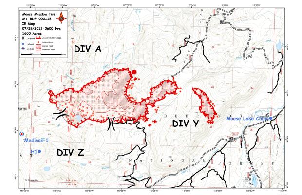
Special Messages/Closures: Displaced Evacuees may call the Department of Emergency Services at (406-360-1626). An evacuation shelter has been established at Granite High School in Philipsburg.The fire area is under a Forest Closure Order No. 2013-D8-027 because of concerns for public health and safety. The following trails are closed: 8109, 8020, 8162, 8019 and 8161.
###
Released: 7/28/13
BEAVERHEAD-DEERLODGE NATIONAL FOREST
Pintler Ranger District
Philipsburg, Montana
Order No. 2013-D8-027
FOREST ORDER
Pursuant to Title 36 Code of Federal Regulation 261.50 (a), the following acts are prohibited on the
Beaverhead-Deerlodge National Forest. This temporary restriction is in addition to those enumerated in
Subpart A, Part 261, Title 36, Code of Federal Regulations and will remain in effect from July 26, 2013 until
September 30, 2013 unless rescinded earlier.
36 CFR 261.53 – Special Closures: It is prohibited to go into or be upon any area which is closed for the
Protection of “Public Health and Safety” (Title 36 CFR 261.53(e)).
For the purpose of this order, the area described generally as Whetstone Ridge is closed to all unauthorized occupancy for public safety from July 26, 2013 until September 30, 2013 unless rescinded earlier. The closure area description follows with a map attachment.
Area Description:
The location of this restriction is described as all National Forest Lands within T4N, R17W, Sections 11 through
15, 21 through 24, 25 through 28, 33 through 36; T3N, R17W, Sections 1 through 4, 11 through 13; T4N, R16W,
Sections 7 through 9, 15 through 23, 26 through 35; T3N, R16W, sections 4 through 8, 17, and 18.
36 CFR 261.54 – National Forest System Roads. When provided by an order, the following are prohibited:
Using any type of vehicle prohibited by the order (Title 36 CFR 261.54(a)).
For the purpose of this order, the Forest roads described below are closed to all motorized vehicles, all bicycle, foot and horse travel for public safety from July 26, 2013 until September 30, 2013, unless rescinded earlier.
The roads closure description follows with a map attachment.
Roads Description:
County Road, commonly known as Middle Fork Road, beginning in T5N, R15W, section 16 NW ¼ to its end including all National Forest roads and trails originating within the closed portion.
36 CFR 261.55 – National Forest System Trails. When provided by an order issued in accordance with 261.50 of this subpart, the following are prohibited on a National Forest System trail: Being on a trail (Title 36 CFR 261.55(a)).
For the purpose of this order, the trails described below are closed to all motorized vehicles, all bicycle, foot and horse travel for public safety from July 26, 2013 until September 30, 2013, unless rescinded earlier. The trails closure description follows with a map attachment.
Trails Description:
Trail #8109 beginning in T4N, R16W, section 22 NE ¼ to its end located in T4N, R16W, section 28 SE ¼. Trail# 8020 beginning in T4N, R16W, section 9 NE ¼ to its end located in T3N, R17W, section 11 NE ¼. Trail # 8162 beginning in T4N, R17W, section 12 NE ¼ to its end located at the junction of Trail #8020 in T3N, R17W, section 2 NE ¼. Trail # 8019 beginning T4N, R16W, section 6 SE ¼ to its end located at the junction with Trail #313 located in T3N, R18W, section 1 SE ¼. Trail #8161 beginning in T5N, R17W, section 1 NE ¼ to its junction with Trail #8019 located in T4N, R17W, section 12 NW ¼.
Exemptions:
Pursuant to Title 36 CFR 261.50 (e), the following are exempt from this restriction:
1. Persons with a permit specifically authorizing the otherwise prohibited act or omission.
2. Owners or lessees of land in the area.
3. Any Federal, State, or local officer, or member of an organized rescue or fire fighting force in the
performance of an official duty.
Done at Philipsburg, Montana this 26th day of July, 2013.
/s/ Peri R. Suenram
________________________________________
PERI SUENRAM
Acting Forest Supervisor
Penalty:
Violation of these prohibitions is punishable by a fine of not more than $5,000 for an individual or $10,000 for an organization, imprisonment for not more than 6 months, or both (16 USC 551 and 18 USC 3559 and 3571).
Sources: inciweb.org
2013 The NW Fire Blog
