
Sunday, October 24, 2021 | 1300 hours PT
PACIFIC NORTHWEST (WA/OR) — Strong windstorms predicted by weather forecasters to hit the Washington and Oregon states came true that began on Friday, October 22, 2021 continue to blow on Sunday. More of the same are due to hit multiple areas into Monday, October 25, 2021.
Some areas have been impacted by power outages, while others are faced with additional problems such as trees on powerlines and/or on roadways. This is a summary of the damage assessments, alerts, watches and more.
STORM WATCHES, ALERTS
Long Beach, Washington
Washington Weather Chasers | These chasers are watching and covering a storm in Long Beach today. More updates will be provided as weather reports arrive.
Social Media | Residents report on the Peninsula thunder, wind and rain so far, nothing too bad.
Pacific Coast, SW Interior, Washington
US National Weather Service Seattle Washington | Rain making its way across W WA this morning. Thunderstorms have already been detected across the offshore WA waters this AM & will remain possible for areas along the Pacific coast & the SW interior through this evening. (0945 PT)
Seattle – TRAVEL ALERT!
SR 520 Westbound – Update 1:29 PM : On SR 520 westbound just west of 124th Ave NE (MP 7) there is a collision blocking the right center lane. The Incident Response Team and the State Patrol have arrived on the scene. (1329 PT)
I-5 Southbound – Debris on I-5 southbound at milepost 127.0 near South Tacoma Way beginning at 12:20 pm on October 24, 2021 until further notice. The off ramp to eastbound SR 512 is partially blocked. (1313 PT)
Ocean Beaches – ALERT!
US National Weather Service Seattle Washington | In addition to strong winds, seas along the coast will build to 25-30 feet on Sunday night & persist through Monday. Make sure to keep your distance from the water as large waves can run further up area beaches-potentially carrying debris with them!
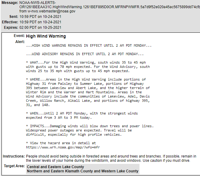
Central and Eastern Lake County, Northern and Eastern Klamath County and Western Lake County (OR) – WARNING
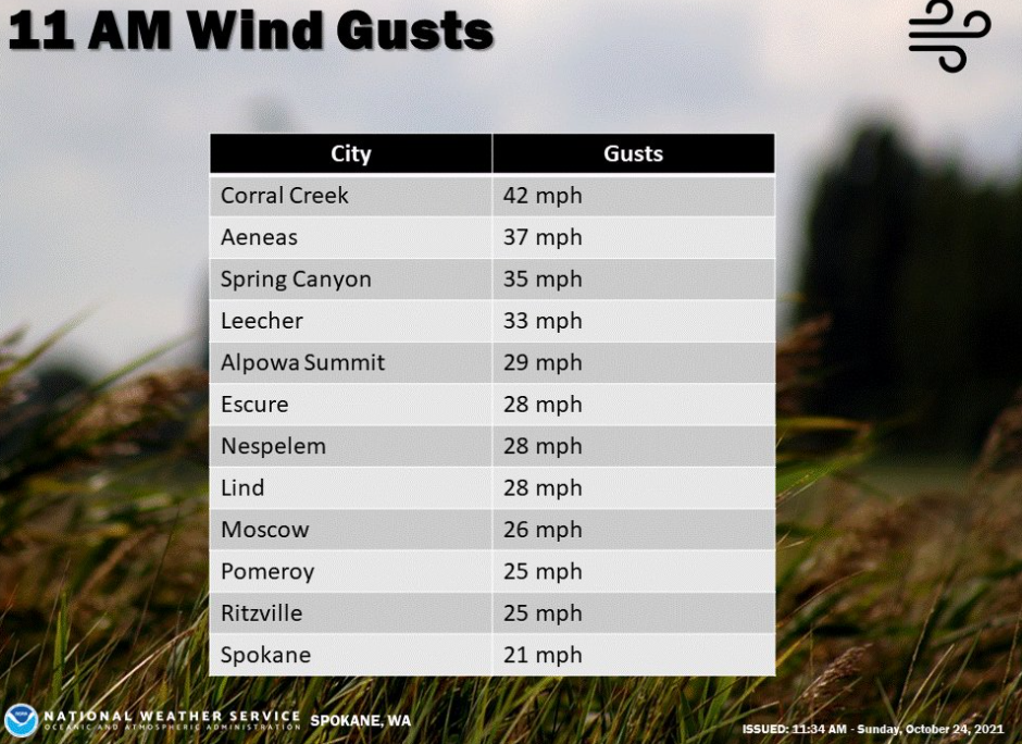
Spokane, Washington and Surrounding Areas
NWS Spokane | It’s been pretty windy. Here’s the proof that the storms are not finished with impacting the northwest. This is to continue throughout the evening into Monday.
CLOSURES, OUTAGES
Issaquah, Washington
228th | Blocked due to trees on power lines and over roadway. (1300 PT)

Ravensdale, Washington
Outages | Power outages in the Ravensdale area. Some road closures around 240th towards Covington. Social Media reports it being a wild morning (1107 PT)
Walla Walla, College Place, Washington
Parks | All have been closed due to safety concerns.
WEATHER FORECASTS
Seattle and Vicinity
October 24, 2021 | Today’s forecast: Breezy. A chance of rain in the morning, then rain at times in the late morning and early afternoon. Showers and a slight chance of thunderstorms late in the afternoon. Rainfall amounts a quarter to a half inch possible, except higher amounts possible in thunderstorms. Highs in the mid 50s to lower 60s. East wind 15 to 25 mph becoming south in the afternoon.
October 24, 2021 | Tonight’s forecast. Breezy. Mostly cloudy. A chance of showers and a slight chance of thunderstorms in the evening, then a slight chance of rain in the late evening and early morning. A chance of rain in the morning. Lows near 50. South wind 15 to 25 mph becoming southeast after midnight. Gusts to 35 mph.
October 25, 2021 | Monday morning forecast. Windy. Rain likely in the morning, then rain at times in the afternoon. Rainfall amounts a tenth to a quarter of an inch possible. Highs in the 50s. South wind 15 to 30 mph with gusts to 40 mph.
RESOURCES
WA Travel Info | Dial 511.
Oregon OEM | Travel Tips

Avoid traveling. Potential for downed trees & power outages.

Keep mobile devices charged and sign up for local emergency alerts: https://oralert.gov


Check your emergency supplies
HASHTAGS
#wawx #orwx
(c) 2021 NW Fire Blog
