

NEW: Friday, August 4, 2023, 2230 PT
A wildfire burning about 66 miles east of Mount Vernon (Skagit County), where we have our home base is starting to see and smell smoke from the ever-changing incident happening on Sourdough Ridge. Rightfully named, the SOURDOUGH FIRE is about 1.5 hours from where we are but can also now be seen in areas, such as Burlington (Skagit), which is north of us, and in Seattle (King) and south of us.

The (above) photo was posted by the North Cascades National Park Service Complex just after 1500 hours and just shows how smokey it had become in the area. We hope the smoke does not impact us as it did earlier on Hwy 20 (photo above). We have already had to start shutting windows because of the heavy smoke in the area. We will see what Saturday brings.
The exact location of the SOURDOUGH FIRE is north of Diablo Lake along the Sourdough Ridge which is between Sourdough and Bucket Creeks in nearby Whatcom County, Washington.

(L) Photo Credit: WSDOT North
The town where this wildfire is located is a small unincorporated community on the Skagit River in the western foothills of the North Cascades.
The wildfire was sparked by lightning on July 29, 2023, when it began to slowly spread through the rocky and steep terrain and has now become more alive and caused more serious threats. Fire behavior was observed as minimal as late as July 31,2023, and estimated at 25 acres.
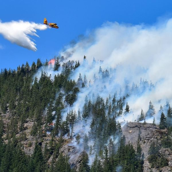
(L) North Cascades National Park Service
Fire behavior has been observed as active with spotting ahead of itself (unsure if it is short-range or long-range), as group torching, flanking, and backing.
The wildfire has burned approximately 2,933 acres and has a 0% containment status.
Structures, transportation, and energy infrastructure are all threatened.
The total CTD is $670,000 for fire suppression and containment efforts.
CLOSED: SR 20 at MP 120-156 as of 2200 on August 4, 2023, until further notice. – WSDOT
CLOSED: Diablo Lake: Trails and waterways. – NCNPSC
There is about 267 total personnel assigned to the wildfire along with three crews, two engines, and two copters.
Incident Cooperators on this incident are the following:
North Cascades National Park Service Complex: Updates and photography. (Above) Photo Credit: NCNPSC.
Whatcom County Sheriff’s Office: They are assisting with evacuation notices and safety educational measures.
Whatcom County Emergency Management: EOC has been activated.
SA IMT 3: IC Mitch Ketron. Trainee Michael Brad.
WSDOT: Traffic alerts, road closures, and monitoring for impact on infrastructure.
Inciweb: Fire Updates.
WSP: WSP District 6 PIO.
NO DRONES IN FIRE ZONES: There are been many drones flying in the area with a TFR (temporary flight restriction) set by the FAA to keep drones/UAVs out of the area but no one seems to be listening about the dangers you put on firefighters in the skies and on the ground. A TFR is in place for a reason.
#NoDronesInFireZones

Incident Cooperators on this incident are the following:
Whatcom County Sheriff’s Office: Sheriff Deputies are assisting with evacuation and safety measures.
Whatcom County Emergency Management: EOC activated.
Social Media is all ablaze with multiple citizen journalists reporting what they are seeing on the ground. Here are a couple of accounts as talked about on the Social Media Channels we monitor:
“The [Fire] can be seen in Burlington (Skagit Co) and Seattle (King Co).”
“Haze starting to impact over Metro Vancouver BC.”
“A Pryocumulonimbus is happening, the area is not setting up for a thunderstorm.”
(c) 2023 NW Fire Blog
