

Hurricane Milton
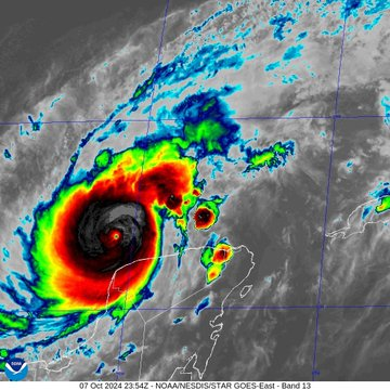
Photo Credit: National Hurricane Center | NOAA
Storm Forecasters and Watchers are saying #HurricaneMilton is now a Cat 5 with winds of 180 mph (1446 PT) and tied as the 3rd strongest hurricane in Atlantic history.
SIT REP 1: 10/7/2024, MONDAY UPDATE
We are working to provide a glimpse into the preparation and share Alerts, Evacuations, and News as they pertain to #HurricaneMilton only. Please visit the Official Agencies and their websites and Social Media links for up-to-date information.
With this incident evolving so quickly, we want you to visit these “Official” sites for more current emergency information.
We encourage those to heed all lawful orders and please evacuate if told to do so, because you, your family, and pets are important and cannot be replaced but your home and the things in it. We understand but you are too important to lose.
Some are saying #HurricaneMilton could bring 15 feet of storm surge to the Tampa Bay area which is the same amount as what Ian brought to Fort Meyers Beach in 2022. This is also what Helene brought to Keaton Beach this year.
PUBLIC SERVICE ANNOUNCEMENTS, ALERTS
EVACUATIONS
About 51 Florida Counties are under mandatory evacuations, according to the sources.
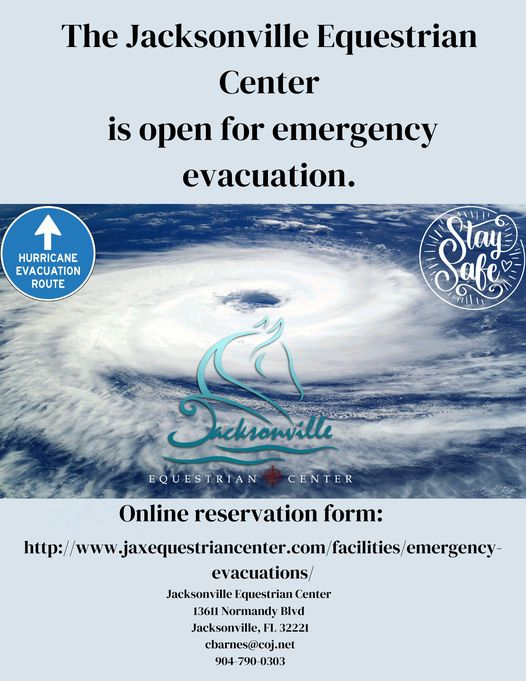
Evacuation Shelter: Jacksonville Equestrian Center: Online reservation form: http://www.jaxequestriancenter.com/facilities/emergency . 13611 Normandy Blvd, Jacksonville, FL 32221. Phone #: 904-790-0303. They have stalls and full hook-up RV sites.
10/08/2024 0600 Hours EDT (0300 Hours PDT). City of Naples (FL), Mandatory Evacuation Order. https://twitter.com/NaplesPolice/status/1843435286346268754/photo/1 (Source: Naples Police Department, 10/7/2024 1636 PT/1936 ET)
10/07/2024 1645 Hours PDT. Citrus County (FL).
10/07/2024 1600 Hours PDT. Hillsborough County (FL). Mandatory Evacuations.
GO KITS (PREPAREDNESS)
The Halter Project is giving away free preparedness Go Kit lists and tips. halterproject.org.

TRAVEL
Airports: Tampa and Orlando are monitoring conditions closely and travelers should be aware of possible cancellations. Cruises have route changes and theme parks like Disney and Universal may adjust operations to ensure safety. (Source: Swift Passport Services, 10/7/2024.) https://bit.ly/3TXZ7bdG
COMMUNITY NEWS
ANNA MARIA ISLAND (Near Tampa, FL): News outlets have visited the area this morning and are showing images of what #HurricaneHelene, a Cat 4 Hurricane did to the area after it was destroyed in its path. Now, the area is having to evacuate yet again due to #HurricaneMilton, a Cat 5 heading directly to their location yet again.
CLEARWATER BEACH: Effective October 7th at 1900 hours ET, access to the barrier islands including Clearwater Beach was restricted to only residents, business owners, and their employees, ride-share drivers and debris haulers will be allowed access until it is shut down on Tuesday at 1900 hours.
INCIDENT COOPERATORS
Tampa Hospital
Photo Credi: Tampa General Hospital
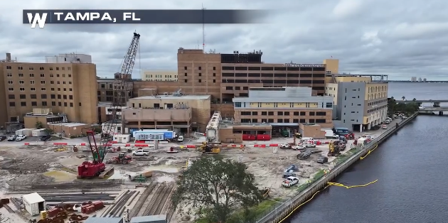
The Tampa General Hospital has installed an AQUA FENCE to protect it up to 15 feet of surge, while others are swallowed by water.
In this photo (L) appears to be on its own island but it was protected by the high waters that impacted the area from #HurricaneHelene.
Hillsborough County Sheriff’s Office (FL)
Today, Deputies throughout the area repositioned assets in locations to be safely stored and easily accessible after Hurricane Milton passes through the area. They are ready at the moment for anything that their communities may need.
As of 1600 hours PT, the SO was asking their residents to evacuate as orders were in effect.
Los Angeles City Fire Department
The LA City FD is sending 43 members after FEMA activated the National Urban SAR Response System. They will be providing a response to the southeast area.
Seattle Fire Department
Photo Credit: Pierce County Emergency Management Agency

More than a dozen members of the Seattle Fire Department deployed today with the WA State TF-1.
Washington State Task Force 1
Washington State Task Force -1 to support those impacted by Hurricane Helene and now possibly Hurricane Milton. The WA State Task Force 1 – FEMA USAR Team includes those from Pierce County SO, SFD, South King Fire, Tacoma Fire Department, Valley Regional Fire Authority, Central Pierce Fire & Rescue, West Pierce Fire & Rescue, Bellevue (WA) FD, Puget Sound Fire, Shoreline FD, Renton RFA, Gig Harbor Fire & Medic One, Mercer Island FD, Bothell FD, Redmond WA Fire, CDA FD, Kirkland FD, Eastside Fire & Rescue, Tacoma Public Utilities, Pierce County Planning & Public Works and Pierce Co EMA. This task force consists of 218 members plus K9 SAR teams.
Colorado USAR Task Force 1
The CO TF-1 has completed operations in North Carolina and has now been redeployed to the State of Florida where they will stage in getting ahead of the hurricane.
California USA Task Force 3
Photo Credit: CA TF-3
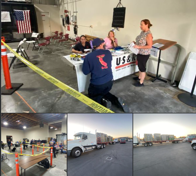
The CA TF-1 deployed a 26-member Ground Crew left on Sunday at 0500 hours, while the remaining members will fly to Florida.
United Cajun Navy
UCN: The newest NHC Outlook validates the latest recon data and has Milton’s max winds at 180 MPH. Landfall is expected between Cedar Key and Ft Myers with the center of circulation over Tampa/St. Pete. Milton is likely to come ashore Wednesday afternoon-evening as a Cat 3 or 4 with max winds of at least 125 MPH. The storm is forecasted to encounter some hostile wind shear before landfall, which will hopefully cause some disorganization.
Regardless, Milton will likely be the most powerful hurricane to hit this area in over 100 years. Mandatory and voluntary evacuations are in place across Florida’s west coast due to the surge and flooding rains. See below for a FREE shuttle service tomorrow to safe locations.
Latest inundation maps for the Tampa/St. Pete area show a peak surge of 8-15+ feet on Wednesday based on the NHC’s current track.
Milton is also expected to increase in size in the next couple of days, expanding its impacts across a larger area. Daily adjustments to the track and intensity are guaranteed between now and Wednesday, so please keep coming back for the latest.
Savannah (GA) Mayor Van Johnson
The National Hurricane Center placed us on a Tropical Storm Watch and a Storm Surge Watch until further notice.
Although we are not presently in the error cone, as we learned recently, we don’t have to be hit by a storm to be severely affected by a storm.
(c) 2024 NW Fire Blog
