

LEVEL 3 EVACUATIONS (GO NOW!) are in effect for: Hunters Point, Oaksprings area, south and east of the Pipeline road.
LEVEL 2 WARNING (GET SET) is now in effect for those west of mile marker 12 on Navajo Route 12 north to the El Paso Gas Station and those north of the El Paso Station.
The fire has now burned well over 1,800 acres, and there is a 0% containment status listed. A CIMT or known as a Complex Incident Management Team, will assume command at the Command Center at 0600 hours on Monday, June 30th.
3 | June 29, 2025 @ 1305 hours PDT
This wildfire is located about 22 miles northwest of Gallup and is being led by the Navajo Region of the Bureau of Indian Affairs (BIA) and has a CIMT (SW Team 2) mobilizing.
Photo Credit | 25th Navajo Nation Council
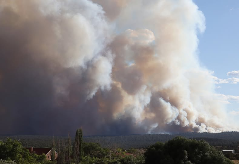
According to the NIFC’s early morning report, that there have been 800 acres burned. There is still a sustained 0% containment status. There has been no caused rule as of yet and it is still under investigation.
About 59 total personnel including one crew, four engines, and a single helicopter, are assigned to this incident.
About $125,000 is the current cost-to-date.
Additionally, fire behavior has been observed as active with crowning, short crown runs, and flanking. Structures are under threat, and evacuation orders have been issued, with many residents evacuating.
Early this morning, around 0130 hours, the Navajo Nation’s President Buu Nygren provided this update.
A briefing was made by the President, with several council delegates, and emergency response personnel with the Incident Command, in how the fire has burned over 1,000 acres, with a zero containment status.
Police indicated they have two persons of interest, who have been identified to be the ones who created a small fire by cutting wood. The small fire would turn into what it is today, after winds picked up embers and quickly turned into a firestorm.
He continues to say there is not a massive evacuation order issued but that 15 families living within the fire perimeter have self-evacuated, with some to the shelter in Fort Defiance and others to different places, where they are reported as being safe.
A press release by the 25th Navajo Nation Council: The current size is now 1,800 acres with a 0% containment status. According to the update, there have been no reports of injuries or structures damaged.
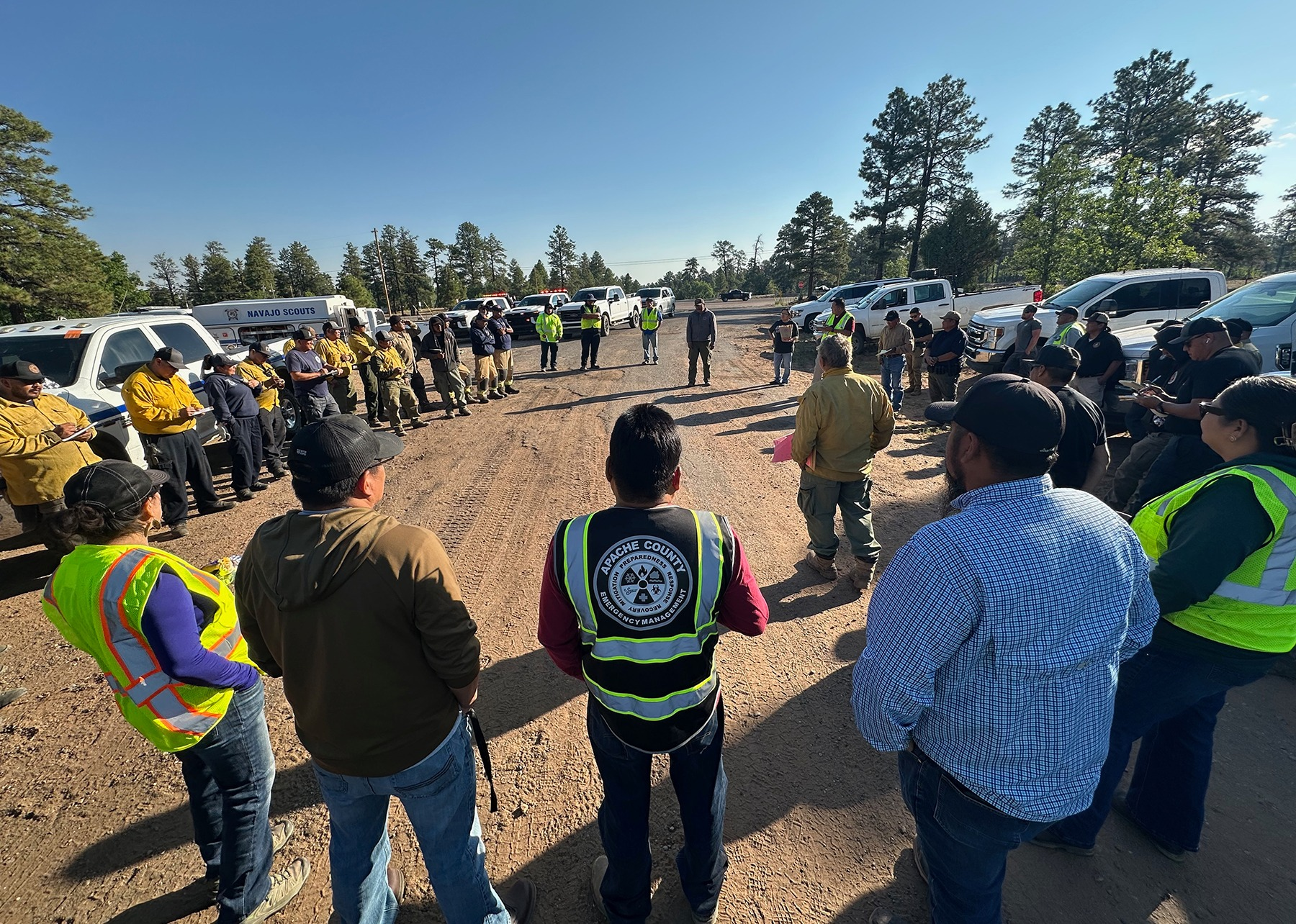
Incident Cooperators include: BIA Navajo Region Fire Management, BIA Rangers, BIA Navajo Scouts, the Apache County Sheriff’s Office, Navajo Nation Forestry Department, Apache County government, Navajo Tribal Utility Authority, Apache County Emergency Management, McKinley County Fire & Rescue, the Bee Holdzil Fighting Scouts Events Center (evacuation shelter), and the Navajo Nation Public Safety departments. A TFR is in effect, though not stated in the release, other that drone flights are prohibited.
Photo Credit | 25th Navajo Nation Council
WILDCAD.NET resources have been dispatched within the last two days, which include the following:
AZ Dispatch Center | A resource order was deployed through the Arizona Dispatch Center, a state resource CAD system (wildcad.net) at 0608 hours MT to respond to this incident, including the following: DIV 3, Aviation 7-2, Chief 3, BC 3-4, BC 7-3-1, BC 4-1, DIV 4, and Chief 2.
AZ Flagstaff Dispatch Center | Resources were dispatched at 1236 hours MT on Saturday, June 28, 2025, for Incident and Event Support staff.
AZ Prescott Dispatch Center | At 0811 hours, resources were deployed through this Communications Center to respond to the Navajo Region Fire and Aviation Management location. At 0822, two aircraft were listed as part of a flight plan in PDC airspace. This included Tankers T-132 and T-136.
SIT REP 2 | June 28, 2025, @ 1830 hours PDT
A current evacuation order has been issued for those within the Oak Ridge Fire area. Fire and Law Enforcement Officials are asking residents, visitors, and the alike, to not stop or park along Hwy 264 to record what is happening in the area. It is dangerous, and if there is an emergency, you will be pulling resources away that are needed to fight the fire. Please be careful out there and listen to all “officials” who are giving folks directions and orders.
SHELTER: Window Rock Fighting Scouts Event Center. For Defiance, Arizona. Contact: Benita Jay for Shelter Accommodations or info: 505-728-3654.
CLOSED: Pine Springs Road off of HWY 264.
SIT REP 1 | Saturday, June 28, 2025 @ 1730 hours PDT
The OAK RIDGE FIRE started on June 28, 2025, from an unknown cause that is located about five to eight miles west of Saint Michaels in the State of Arizona (USA).
It broke out on the summit known to locals as “Oak Ridge”. It is located west of Saint Michaels, which was reported at 1348 hours MT.
Photo Credit | Navajo Nation

It is also being called the SUMMIT ROAD FIRE by the Navajo Police Department (per their Facebook Page), which is confusing on which incident name it should be listed as, but a second source is listing by our Fire Name for this post.
Incident Cooperators include the following:
- Navajo PD
- Navajo Nation Fire
- Navajo Regional Fire Dispatch
- BIA Wildland Fire Management – Navajo Region
- Navajo Nation President Buu Nygren
- Navajo Nation Department of Emergency Management
The fire has burned about 10 acres of Pinyon and Juniper (fire fuels).
A temporary Fire Command has been established. Navajo Nation Fire and BIA have two air tankers working and dropping over the fire. Hotshot crews are also assigned to this incident.
The Navajo Nation President is working on coordinating with emergency teams with multiple Incident Cooperators.
(c) 2025 NW FIRE BLOG
