

Incident: West Fork Complex Wildfire
Released: 5 hrs. ago
A fire information meeting will be held on Tuesday, June 25 at 2:00 pm at the Creede High School Gymnasium. Fire officials will be present to provide and update to the community on the status of the West Fork Complex.
Credit: Blakeman
###
Released: 9 hrs. ago
West Fork Complex Fire Update
Phoenix National Incident Management Organization- Curtis Heaton, Incident Commander
Rocky Mountain Incident Management Team- Pete Blume, Incident Commander
West Zone Information Center: 970-731-2745 or 970-731-2432
East Zone Information Center: 719-569-4149
Hours of operation: 8:00 am 9:00 pm
West Zone Email: westforkfire@gmail.com
East Zone Email: WestForkFire.EastZone@gmail.com
Credit: Schlapfer
June 24, 2013
10:00 am
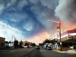
Special Message: An air quality monitor has been set up in Del Norte. The monitor is used to measure the effects of the smoke in the area. The readings the monitor takes can be viewed at http://www.wrcc.dri.edu/cgi-bin/rawMAIN.pl idsmf1. Documents explaining the readings will be posted on Inciweb at http://inciweb.nwcg.gov/incident/3436/.
Current Situation:
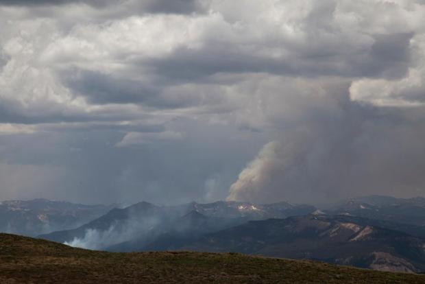
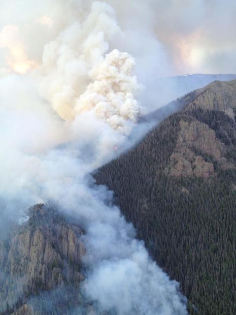
Papoose Fire: Yesterday the fire continued to back down towards Highway 149. Firefighters were successful in keeping the fire from impacting structures, and to date no confirmed structures have been damaged or destroyed. Today firefighters will continue structure protection along the northern perimeter of the Papoose Fire and north along Highway 149 in the event that the fire pushes to the north. On the northwest side, the fire has slopped over the Rio Grande Reservoir Road (FSR 520). Additional resources have been assigned to this area in an effort to keep the fire from moving north.
East Zone of West Fork Fire: Today firefighters, with assistance from air resources, will continue to work along Highway160 to keep the fire in check as it moves towards the highway. A dozer line has been created between the eastern edge of the fire and the community of South Fork. Firefighters will work to improve and reinforce the line today. Along Highway 149, firefighters will continue to clear vegetation and provide structure protection to structures west of the highway. East of Highway 149 near South Fork, structure protection is in place in the event that the fire pushes to the east and spots across the highway. To date no confirmed structures have been damaged or destroyed in this zone.
West Zone of West Fork Fire: The West Zone of the West Fork fire is the portion of the fire burning south of the continental divide. The segment on the south end of the fire that made a run up the backside of Sheep Mountain turned north yesterday burning back towards the main body of the fire. There is still concern that burning in this area could move to the west posing a threat to Highway 160. Firefighters did a structure protection assessment in the Bruce Spruce Campground along West Fork Road yesterday and will be establishing a sprinkler system to protect the structures in that area today. Structure protection remains in place for Borns Lake.
Windy Pass Fire: The Windy Pass Fire made a run in the Lane Creek drainage but it did not gain much in acreage since a good portion of the fire activity was within the existing fire perimeter. The fire went from 987 acre yesterday to 1,244 acres this morning. It did not cross over into the Wolf Creek Ski Area. Firefighters have been able to hold the Windy Pass Fire within the established indirect containment lines protecting the Wolf Creek Ski Area.
Weather: Another Red Flag Warning is in effect today due to low relative humidity, gusty winds, and a Haines Index of 6. Winds are predicted to be out of the southwest 15-25 mph gusting to 35. Wind gusts could reach 50 mph on the ridge tops. Relative humidity will be 11-16 percent, and the Haines Index is 6. The Haines Index measures the stability and dryness of the air over the fire. A Haines Index of 6 indicates that there is a high potential for extreme fire behavior, intensity, and growth.
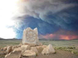
Evacuations and Closures: No additional closures or evacuations have been issued. Beginning today at 9:00 am, local traffic from Creede is being escorted between Wagon Wheel Gap and Highway 160. This is for residents of Creede and those areas not evacuated along Highway 149 near the Papoose Fire.
Highway 160 from the chain-up area to South Fork remains closed. Visit www.cotrip.org/roadConditions.htm for more information.
For additional information on road and trail closures affecting the San Juan National Forest go to: http://www.fs.usda.gov/alerts/sanjuan/alerts-notices.
For additional information on road and trail closures affecting the Rio Grande National Forest go to: West Fork Fire Closures.
Public Briefing: A briefing for evacuees and affected residents will be held daily at the Red Cross Shelter in Del Norte at 9 am.
Media Briefings: Media briefings will be held at 9 am and 9 pm daily at Centennial Park in Del Norte.
Fire Statistics:
Location: 14.5 miles north/northeast of Pagosa Springs, CO
Start Date: 06/05/2013
Complex Size: 75,150 acres
Percent Contained: 0%
Windy Pass: 1,244 acres
Papoose: 20,927 acres
West Fork: 52,979 acres
Cause: Lightning
Total Personnel: 895
Resources Include: 4 Type 1 hand crews, 21 Type 2 hand crews, 50 engines, 10 water tenders, and overhead personnel
Air Resources: 3 Type 1 helicopters, 2 Type 2 helicopters, and 4 Type 3 helicopters
Places to get information:
Website: http://inciweb.nwcg.gov/incident/3436/
Twitter: Follow the Rocky Mountain IMT at @rmt1pio
Facebook: The Rocky Mountain IMT has a Facebook page dedicated to thank yous to the firefighters working
on the fire line. Visit the page at https://www.facebook.com/RockyMtn.Type1.IMT.PIOs.
Information Boards: Information is posted at the Pagosa Springs Visitor Information Center. Information
boards are being constructed and will be going up at Freemons Ranch near Creede, the Forest Service office
in Creede, and at the Red Cross Shelter in Del Norte.
Photos: A web album has been created, and we will be uploading photos to http://s1286.photobucket.com/user/WestForkComplex/library/
###
Released: 10 hrs. ago
When you want to help.
In a time of crisis people naturally want to reach out and help. We appreciate those efforts and have developed a list of suggestions.
Most appreciated by firefighters:
>Thank you notes and banners
>Donations to Wildland Firefighter Foundation at http://www.wffoundation.org/
What we cannot accept:
>Food items- due to health and federal contract regulations
Note: Local food bank donations tend to decrease when the public chooses to donate their food to fire camp- we feed our assigned fire crews three meals a day including snacks.
The Best Suggestions:
>Join or support your local volunteer fire department or emergency organizations- they need your generosity since they are the first responders in many cases.
>Donate to local charitable organizations like the Red Cross.
>DEFENSIBLE SPACE AROUND YOUR HOME- give emergency responders and yourself a safe area to retreat to or to defend your home in.
> For other ways to volunteer or make donations dial 2-1-1 or visit http://helpcoloradonow.com/
Thank you for your cooperation!
Reblogged: 6/24/13 1940 PDT
2013 The NW Fire Blog
