

Douglas Complex Fire Update; Tuesday, 7/30/13 @ 9 AM
Incident: Douglas Complex Wildfire
Released: 12 hrs. ago
Oregon Department of Forestry Team 2- Dennis Sifford, Incident CommanderOregon State Fire Marshal Office Green Team – John Ingrao, Incident Commander Phone Numbers: 541-832-0136; 541-832-0137Douglas County Information Number: 888-459-3830Hours of operation: 8:00 am – 9:00 pm
July 30, 20139:00 am

Special Message: Josephine County Sheriff issued a road closure order yesterday afternoon due to fire activity in the area. Lower Wolf Creek Road is closed from the town of Wolf Creek to the Water Tank drainage and Grave Creek Bridge to the Water Tank drainage. Josephine County Sheriff also issued an evacuation order for all residences on Lower Grave Creek Road from the Grave Creek Bridge to Lower Grave Creek Road and Lower Grave Creek Road at the intersection of Lower Wolf Creek Road to the Water Tank drainage on Lower Wolf Creek Road. A Conflagration was invoked for Josephine County, allowing State Fire Marshal office to provide structure protection in the county.
The Farmer’s Fire, a fire that has been burning for several days in the Grants Pass Unit (Oregon Department of Forestry) will become part of the Complex. This fire is approximately 200-400 acres.
The Governor has declared a State of Emergency for Josephine and Douglas Counties.

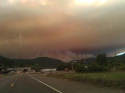
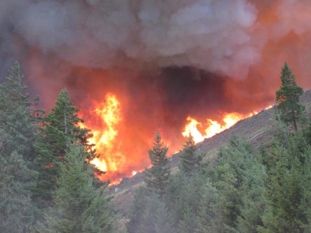
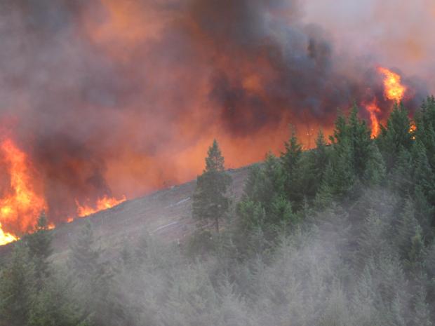
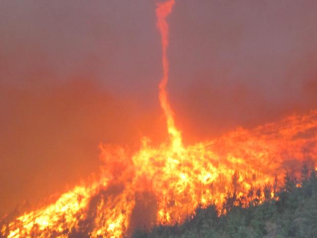
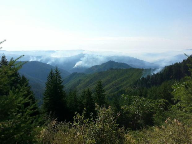
Current Situation: The Douglas Complex has been divided up into three branches – Milo, on the east side of Interstate 5; Rabbit Mountain, on the west side of Interstate 5, northwest of Glendale, and Dad’s Creek, west of Glendale. Fire continues to burn actively on the east side of the interstate. Firefighters are contending with hazards, like falling boulders and trees, and old mine shafts, which are affecting access into some of the fire area. Values at risk include homes, commercial timberland, and critical wildlife habitat. There are no reports of homes burned. One minor injury has been reported.
MiloMilo Branch is a group of smaller fires, all less than 20 acres in size. Firefighters will begin patrol of these fires. Minimal fire activity is expected today for this branch.
Rabbit Mountain Firefighters are making progress on line construction on the north end of the fire, near Middle Creek. Rugged terrain on the west side of the fire is a concern, and the south end of the fire continues to burn actively.
Dad’s CreekThe south end of the fire continues to burn actively, near Poorman Creek; however, growth has slowed. Line has been established from Cow Creek to the north part of the fire. Line constructed by dozers has been established behind the homes for protection. Overnight, were able to take advantage of the cooler temperatures and higher humidity to conduct a small burnout operation on the east side of the fire, establishing a containment line to protection the City of Glendale. Burn out operations will continue when weather is conducive. Citizens may see smoke coming from that activity. State Fire Marshal Office will provide protection in the Grave Creek area as well as continue protection in other evacuated areas of the fire. The fire is expected to burn actively again in the afternoon when temperature increases and winds start to affect fire movement. Smoke and erratic winds may impact air operations. Areas around Glendale will see more smoke in the area, mostly during the morning hours.

Weather: A threat of dry lightning and thunderstorms is expected Tuesday night through Wednesday. There is a chance for rain on Wednesday and Thursday, and then a drying trend Friday through the weekend.
Evacuations and Closures:
Cow Creek Road from Riddle into the fire area and from Glendale into the fire has been closed. The public is asked to honor the road blocks and not interfere with firefighters working in the area.
Evacuations have been ordered for McCullough Creek Road, Reuben Road, and Mt. Reuben Road in Douglas County, and Poorman Creek Road in Josephine County.
An additional four hundred residences are considered threatened. This means evacuations could be necessary at some point in the future. Any official evacuation orders would be issued by the Douglas County or Josephine Sheriff’s Offices.
Fire Information Meetings: Yesterday, a public meeting was held at the Glendale Elementary School with approximately 500 people in attendance. Updates were provided by the Glendale Fire Chief, Douglas County Sheriff, State Fire Marshall Office, both teams managing the Complex, Bureau of Land Management, Douglas Forest Protective Association, and American Red Cross.
Public Safety/Prevention: Due to winds transitioning from the northwest and inversions setting in at night, thick smoke from the Dad’s Creek fire is settling into Glendale during the morning hours. To address any concern as a result of smoke in the area, an air quality sensor has been installed in Glendale. Go to www.oregonsmoke.blobspot.com to track air quality measurements.
Douglas Forest Protective Association has increased prevention restrictions to IFPL 3, where a 1 p.m. shutdown is in effect. Public restrictions are also in place. Check www.dfpa.net before your activites.
Fire Statistics:
Location: 7 miles north of Glendale, OR
Percent Contained: 5%
Complex Size: 21,400 acres
Cause:Lightning
Start Date: 7/26/13
Total Personnel: 1260
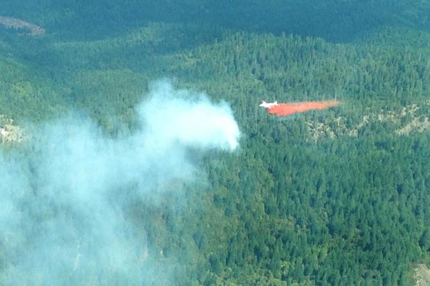
Resources Include: 39 Type 2 hand crews, 75 engines, 8 dozers, 26 water tenders, and overhead personnel
Air Resources: 3 Type 1 helicopters, 6 Type 2 helicopters, and 2 Type 3 helicopters
###
Minor correction to evacuation update – Monday, 7/29/13 @ 5:45
Evacuation Update Correction
We have received updated information from Josephine County regarding the evacuations put in place.
Evacuations:Graves Creek bridge to Lower Graves Creek Road/Lower Wolf Creek Road. Lower Wolf Creek Road to Water Tank Drainage on Lower Wolf Creek Road.
Road Closures:Roads Closed at Graves Creek Bridge, water tank drainage as well as Lower Wolf Creek Road from the town of Wolf Creek to the Water Tank drainage.
Oregon Department of Forestry Team 2- Dennis Sifford, Incident Commander Oregon State Fire Marshal Office Green Team – John Ingrao, Incident CommanderHours of operation: 8:00 am – 9:00 pmPhone Numbers: 541-832-0136; 541-832-0137Douglas County Sheriff’s Office Information Line: 1-888-459-3830
July 29, 20133:00 p.m.
Additional Homes Evacuated in Josephine County
Josephine County Sheriff issued a road closure order this afternoon due to fire activity in the area. Lower Wolf Creek Road is closed from the town of Wolf Creek to Leland Road. Lower Graves Creek Road is closed from Leland Road to the Rogue River. Josephine County Sheriff’s Office also issued an evacuation order for all residences on Lower Graves Creek Road from the Graves Creek Bridge to Leland Road, Lower Wolf Creek Road, and from Lower Graves Creek to Water Tank Gulch. This new evacuation order affects an estimated 30 residences.
Evacuation orders are still in effect for:
• McCullough Creek Road, Reuben Road, and Mt. Reuben Road in Douglas County, and Poorman Creek Road in Josephine County.
Citizens can evacuate to Glendale Elementary School or Josephine County Fairgrounds:
• Glendale Elementary School is located at 100 Pacific Avenue in Glendale.• Josephine County Fairgrounds is located at 1451 Fairgrounds Road in Grants Pass.
For more information, call Red Cross at 888-680-1455.
Fire Statistics: Location: 7 miles north of Glendale, ORPercent Contained: 2%Complex Size: 21,000 acresCause: LightningStart Date: 7/26/13Total Personnel: 1024
Resources Include: 38 Type 2 hand crews, 29 engines, 2 dozers, 8 water tenders, and overhead personnel
Air Resources: 3 Type 1 helicopters, 5 Type 2 helicopters, and 3 Type 3 helicopters
Places to get information:
Douglas Forest Protective Association – www.dfpa.net
Twitter –www.twitter.com/DouglasFPA
Facebook –www.facebook.com/DouglasForestProtectiveAssociation
InciWeb –http://inciweb.nwcg.gov/incident/3559/
ODF PIO Blog –http://wildfireoregondeptofforestry.blogspot.com/
ODF Southwest Oregon District –www.swofire.com
American Red Cross – www.redcross.org/nss
###

The Oregon Department of Forestry (ODF) mobilized ODF Incident Management Team 2 (IC: Dennis Sifford) to manage a group of lightning-caused wildfires in Douglas County called the Douglas Complex that are mainly located in the southern portion of the district and east of I-5. The complex is burning on Douglas Forest Protection Association-protected lands that include Bureau of Land Management and private forest lands.
The team assumed command of the fire suppression effort from DFPA at 0800 hours on Saturday morning, July 27. The incident command post is located at the Glendale High School in the community of Glendale.
The Douglas Complex started Friday morning, July 26, 2013, after 54 fires were ignited by lightning on lands protected by the Douglas Forest Protective Association. A majority of the fires in the Douglas Complex are located in the Cow Creek Canyon west of Glendale. In addition, a handful of fires in the Milo area are included in the Complex. The total number of fires is expected to decrease as several fires in close proximity to each other have burned together.
The below “Basic Information” was updated on effective 7/30/13 at 1500 hours
Basic Information
| Incident Type | Wildfire |
|---|---|
| Cause | Lightning |
| Date of Origin | Friday July 26th, 2013 approx. 02:30 AM |
| Location | 7 miles north of Glendale, OR |
| Incident Commander | Dennis Sifford |
Current Situation
| Total Personnel | 1,260 |
|---|---|
| Size | 21,400 acres |
| Percent Contained | 5% |
| Fuels Involved | 10 Timber (litter and understory)
also 13- Slash 5 – Brush & reproduction |
| Fire Behavior | Active fire behavior on Rabbit Mountain and Dad’s Creek Fires, torching, spotting, and short crown runs have been observed. Steep slopes, dry fuels and low hunidity are hampering fire efforts. |
| Significant Events | Rabbit Mountain and Dad’s Creek Fires had significant growth with extreme fire behavior. Evacuation of 43 structures NW of Glendale along Lower Cow Creek Rd, McCullough Creek, and Rattlesnake Creek and 17 residences on Poorman Creek. Closure of Lower Cow Creek Road, Union Creek, and West Fork. Evacuated an additional 30 residences on Graves Creek Road. Pre-evacuation notice on additional 40+ structures. Good progress made on some smaller fires in the complex. Conflagration resources are conducting structural protection on the incident. A public meeting was held in Glendale. The Governor’s Office has approved a conflagration for fires in northern Josephine County; these fires will be managed as part of the Douglas Complex. |
Outlook
| Planned Actions | Continue to mobilize resources to handle fires on the complex. |
|---|---|
| Growth Potential | Extreme |
| Terrain Difficulty | Extreme |
| Remarks | ODF Team 2 assumed command of the incident 7/27/2013 at 0600. Unified Command with Oregon State Fire Marshal Green Team on 7/27/2013. Structural task force in place with equipment and personnel from Lane, Marion, Lincoln, Linn, and Benton counties. |
Current Weather
| Wind Conditions | 12 mph NW |
|---|---|
| Temperature | 80 degrees |
| Humidity | 30% |
