SIT REP 5 | MAY 17, 2021 | MONDAY
Do you ever want to know a frame-by-frame of a very large fire incident?
The PALISADES FIRE is the third large fire incident in California and this wildfire has gained a lot coverage from the ground and air, to eye witness accounts to Social Media catching fire all on its own.
We use verified sources and other information for this post.
Please Note: We don’t post unverified information or possible potential criminal information unless already released by Fire or Law Enforcement agencies. Even then, we want to cover from the Fire side of things, less Law Enforcement (for Safety reasons).
#
OVERALL INCIDENT SUMMARY
Los Angeles City Firefighters responded to a brush fire call on Friday, May 14th around 2200 hours in the 1800 block of North Michael Lane in Pacific Palisades and impacting Topanga Canyon, California. Evacuations orders and notices have been in effect with area trailheads, roadways and other impacted areas.
No injuries to citizens. One firefighter has been injured. His/Her injuries and condition are unknow at this time.
Ever want a summarized version of a very large fire incident?
Here is our recap through hundreds posts and media coverage.
#
DAY 1 – MAY 14, 2021 – FRIDAY
2202 PT
FS 23; Batt 9; West Bureau; Council District 11; BC17 BC9 CM42 E105 E19 E23 E237 E263 E269 E273 E290 E293 E305 E63 E69 E73 E93 EM17 H1 H2 H5 HA1 HA2 HA5 RA23 T105 T37 T63 T69 T73 T90 T93; CH7; 12 are dispatched.
1800 block N Michael Lane. Pacific Palisades. Difficult access. Remote area. RH is high with almost no wind. 60 LAFD Firefighters assigned along with brush response from LAFD.
2359 PT
Fire progressing slowing. 10 acres.
Units on-scene MEDIA: PIO David Ortiz en route ETA 12:35am. ; FS 23; Batt 9; West Bureau; Council District 11; BC17 BC9 CM42 E105 E19 E23 E237 E263 E269 E273 E290 E293 E305 E5 E63 E69 E73 E84 E88 E93 EM17 H1 H2 H5 HA1 HA2 HA5 PI2 RA23 T105 T37 T63 T69 T73 T90 T93; CH7; 12.
DAY 2 – MAY 15, 2021 – SATURDAY
0104 PT
72 LAFD Firefighters with 4 LA County FD hand crews. 10 acres. Heavy brush and steep terrain. No wind and wet/cool weather conditions. No structures threatened.
Crews on standby for structure protection. Fire not moving. On an extended to suppress and contain. No roads or hydrants. Steep and rough terrain.
0630 PT
Firefighters worked overnight. Estimated 15 acres. No structures under threat. No evacuations in progress. No injuries reported. Weather conditions are still cool and wet. High humidity.
LAFD helos working until 0500 hours. Aircraft leaves for maintenance. Air Ops resumes today with air support dropping water over fire. Due to the steep terrain, firefighters were unable to get lines in to assist with water supply. Crews recycling throughout the day.
FS 23; Batt 9; West Bureau; Council District 11; AR1 BC17 BC18 BC9 CM42 E105 E19 E23 E237 E263 E269 E273 E290 E293 E305 E37 E5 E63 E69 E73 E84 E88 E93 EM17 H1 H2 H5 HA1 HA2 HA5 HE1 PI2 RA23 T105 T37 T63 T69 T73 T90 T93; CH7; 12 on-scene.
1559 PT
1st alarm brush fire response back to the fire. Staging at Santa Maria Road and Topanga Canyon Blvd. Structures threatened. Structure protection group established. Resources being assigned to Division.
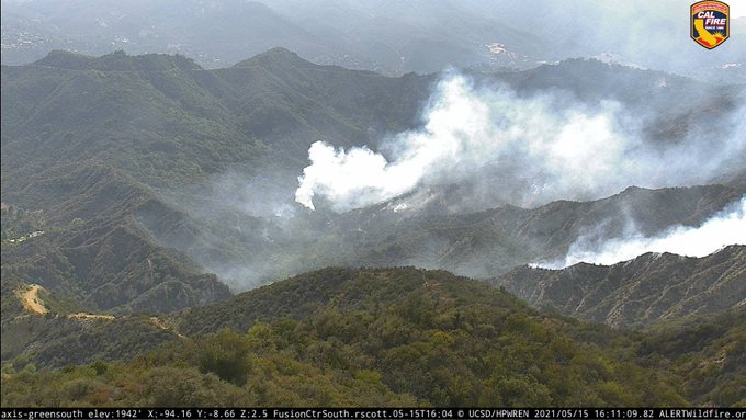
1615 PT
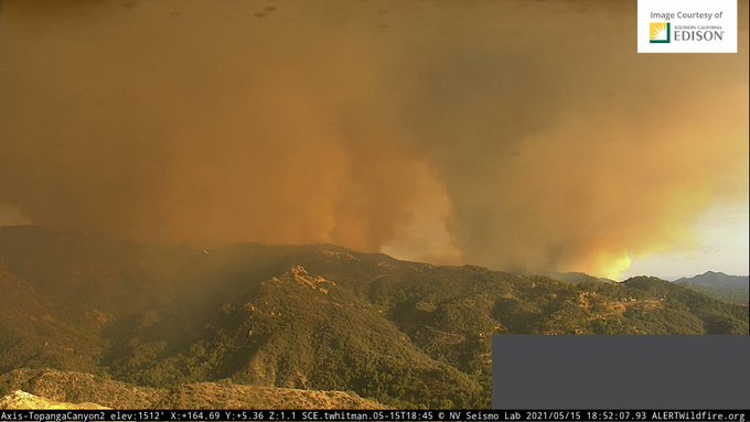
Flare-up within the incident. Large plume visible. 100 acres slop over. Land under threat to the west on in CAL FIRE jurisdiction. Unified Command LAFD, LA County FD and CAL FIRE. Fixed wing air resources approved as needed. Ventura Co FD helicopter also assisting with water drops. No evacuation orders. Bulk of firefighting suppression efforts are by air. No injuries reported.
Units on-scene: FS 23; Batt 9; West Bureau; Council District 11; AR1 BC12 BC17 BC18 BC9 CM42 CM52 E1 E105 E11 E19 E2 E23 E237 E26 E263 E269 E273 E290 E293 E305 E33 E37 E5 E60 E63 E69 E73 E82C E84 E85 E88 E9 E90 E93 E94 EM17 H1 H2 H5 H6 HA1 HA2 HA5 HA6 HE1 PH1 PI2 RA23 RH114 T105 T37 T63 T69 T73 T90 T93; CH7; 12.
1644 PT
Tanker 137 flys over the Glendale community.
1649 PT
Fire being driven by gusty winds from the south-to-southwest directions about 15-25 mph and with humidity at 50% or higher. Fuels are very dry in this area.
1706 PT
Flames flare up when fire hit heavy brush.

1712 PT
LASD Lost Hills Stations prepares to evacuate residents in zone 4 – Cheney Ranch Road and Community of Entrada.
1745 PT
Residents can see a small part of the fire burning on the ridgeline from Palisades Highlands.
1845 PT
Unified Command still in effect. 200-plus acres. 3 burn areas. Main fire, the original fire and small spot fire. No evacuations. No structures are threatened. Moderate rate of spread due to onshore winds. Dozers working. State Parks closing nearby trail systems. No injuries.
Units assigned: FS 23; Batt 9; West Bureau; Council District 11; AR1 BC12 BC13 BC14 BC17 BC18 BC1B BC9 CM42 CM52 E1 E105 E11 E15 E19 E1B E2 E20 E23 E237 E26 E263 E269 E273 E290 E293 E305 E33 E35 E37 E39 E3B E41C E43C E5 E60 E61 E63 E64 E69 E6S E73 E8136 E82C E84 E85 E88 E89 E9 E90 E93 E94 EM17 H1 H2 H5 H6 HA1 HA2 HA5 HA6 HE1 PH1 PI2 RA23 RH114 T105 T37 T63 T69 T73 T90 T93; CH7; 12.
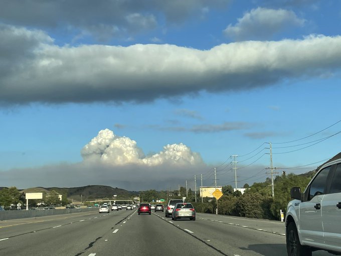
1902 PT
City of Calabasas: “No threat to our City. Photo from the 101 in Agoura.”
2012 PT
Red Cross offering assistance for lodging and other needs, broadcast their contact information at 323-374-3525 or by sending them a DM.
2041 PT
Large animal evacuation shelter released. Pierce College, 6201 Winnetka Avenue, Woodland Hills, CA 91371. Phone: #818-710-4100.
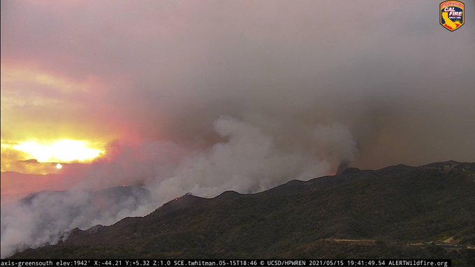
2051 PT
A large pyroculumus cloud (dense cumuliform cloud associated with fire or volcanic eruptions) could be seen above the site of the fire earlier this evening.
2053 PT
LA County Animal: “Small animals” and “Large animals” evacuation alerts are broadcasted. @LACoAnimalCare
2114 PT
Social Media outlets (we aren’t naming them) are posting picture of a “suspected” arsonist. No name, just his photo and encouraging readers to hunt him down. Fire and Police Officials have not released the cause or if this is related to arson.
2119 PT
LASD’s Air Rescue 5 insert the SEB team inside the Topanga area in search for an arson suspect allegedly setting fires.
2205 PT
Fire can be seen by passengers on an air plane flying near the perimeters of the TFR
DAY 3 – MAY 16, 2021 – SUNDAY
0730 PT
Updated acreage and containment not released yet. Weather overnight was cool and moist overnight. Increased temps expected. Fire fuels duly notable that this area has not burned in the last 50+ years.
Mandatory evacuation orders issued on Saturday by LA Co FD, impacting about 1,000 residents. Cause deemed suspicious. Open and active investigation. Copters continued to drop water over the fire line.
PIOs release operational map of fire on @LAFDTalk (Twitter) and @losangelesfiredepartment (Instagram). No structures damaged. No injuries reported. ICP relocated Saturday to Will Rogers State Beach. Media staging is north of lifeguard building.
0836 PT
NB and SB Topanga Canyon Blvd (SR 27) closed by the CAL Trans District road crews.
0842 PT
Smoke plume is growing and seen from Woodland Hills by a resident.
0918 PT
Air resources doing what they do best.
0938 PT
750 acres. 0% containment. Favorable weather settled over fire with lower temps, increased moisture and light winds. Evacuations and road closures in effect.
1020 PT
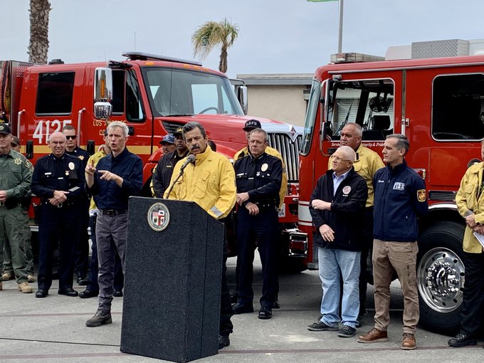
500 fire personnel assigned to incident. LAFD Chief Terrazas along with LAPD Chief Moore, Mayor of LA, CHP, LASD HQ, LA County FD give fire briefing update.
1029 PT
835 acres. 0% containment. Crews working on flare-ups. Helicopters are dropping water.
1044 PT
835 acres. 0% contained. Difficult terrain and many inaccessible area. Heavy equipment improving fire lines.
1055 PT
5 copters including 15, 14 are working on the fire.
1251 PT
1,325 acres. 0% contained.
1400 PT
Evacuation Warning for 1500 block of Chastain Parkway West, all homes north of Chastain Pkway over to Calle Del Cielo (eastern boundary). Warning to Calle De Sarah, Calle Belle Vista and all homes west of Calle Del Cielo/Avenue Ashley up to the hills. Map posted on https://www.lafd.org/newspalisades-fire
1423 PT
Large animals such as horses, livestock evacuating to Pierce College, 6201 Winnetka Avenue, Woodland Hills. Injured wildlife call CA Wildlife Center #310-458-9453 in Calabasas.
1611 PT
1 OCFA helicopter arrives on-scene and 1 Type-3 strike team is en route as mutual aid to LAFD and LA Co FD.
1654 PT
An app that gives alerts to communities was said to have posted the wrong image the arson “suspect” sparking concerns over Social Media. The app later tells news media they made a mistake posting the wrong photo of the suspect and that they “lost” their way. They say they knew a suspect was being sought but they did not coordinate with LAFD or LASD. {media}
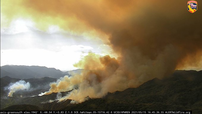
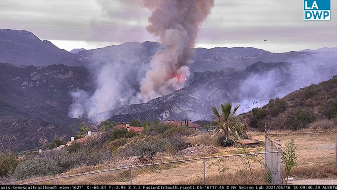
1810 PT
Column seen from the Temescal Trailhead has very active fire behavior and captured by the Green Peak camera.
1858 PT
Helco: “Fire holding along fire road system as a fire break. Western side of the fire is main issue due to flare-ups. Eastern side of fire has some hot spots being worked by the copters.”
2014 PT
Copters 1, 2, 306 focus on the main fire. Flared up on the west flank.
2019 PT
Ventura County Air Unit Copter 2 (Sheriff’s Office) drop water with the aid of Fire Manager and Crew Chief.
DAY 4 – MAY 17, 2021 – MONDAY
0007 PT
News agency reports Sheriff Department detains the main in the photos being passed around Social Media by an emergency alert broadcasting app (not naming names) but is released due to not evidence to charge him. They let him.
1411 PT
Flare-up near Topanga this afternoon. LA Co Fire Ops are working on the fire.
1516 PT
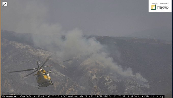
3 fixed wing retardant dropping aircraft continue to work the area along with water dropping copters.
1700 PT
Containment is 23%. Holding at 1,325 acres. No changes to evacuation warning in the City of Los Angeles. Map posted at http://www.lafd.org/news.
1715 PT
Evacuation orders in the Topanga area have been lifted for zones 4 and 6.
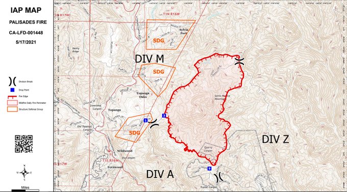
1748 PT
Operational map released by LAFD Talk.
2100 PT
1,325 acres. 23% contained. No injuries to civilians. 1 firefighter injury. 785 structures threatened. 0 structured damaged or destroyed. Successful construction of containment lines is occurring.
Evacuations lifted for Topanga Canyon and Topanga Canyon Blvd to residents only.
Evacuation warning still in effect for the Pacific Palisades are as it is near an active portion of the fire. 1 person has been arrested by the LAFD Arson Section .
50 engines, 2 water tenders, 15 hand crews, 8 helicopters, 6 dozers, 454 total personnel. Incident Cooperators: LASD, LAFD, LAPD, CHP, MRCA, CA State Parks, CAL Trans, LA County Animal Care, LA County OEM, American Red Cross, Crew 8.
(c) 2021 NW Fire Blog
