

Line Fire
Photo Credit: USFS – San Bernardino National Forest

Published Saturday, September 7, 2024, 2210 hours PT
INCIDENT SUMMARY
SAN BERNARDINO COUNTY, CA — A wildfire named the LINE FIRE is burning in San Bernardino County, California. The fire behavior is so extreme, that it is creating its own fire weather, as a massive, mushroom-shaped pyrocumulus cloud can be seen forming above the horizon. The National Weather Service reported that there have been 3,700 lightning strikes with 280 of them striking the ground.
The fire was reported at 1800 hours on September 5, 2024, in the area of Baseline Street and Aplin Street. from an unknown cause which is under investigation.
This incident is approximately 58 miles east of Los Angeles.
RESOURCES
There are currently 628 total personnel along with four helicopters, 65 engines, three dozers, one water tender, and 13 crews, along with other assigned resources.
Unified Command | US Forest Service, Highland City Fire, San Bernardino County Fire, CAL FIRE, and San Bernardino County Sheriff’s Office.
Orange County Fire Authority | The OCFA has sent Type 1 and Type 3 strike teams along with a Type 1 hand crew, one dozer, and QRF helicopters as mutual aid.
US Forest Service – San Bernardino National Forest
City of Highland Fire Department
San Bernardino County Fire Department
San Bernardino County Sheriff’s Office
Immanuel Baptist Church
Devore Animal Shelter
San Bernardino Police Department | Evacuation Orders were issued for the areas north and east of Highland and Palm Avenues. Their Officers are on-site assisting residents with the evacuation process. (Source: SBPD, 9/7/2024 1938 PT)
Los Angeles Fire Department | Deployed Strike Team of 22 Firefighters, which includes E209 (Central City), E10 (Convention Center District), E13 (Pico-Union/Koreatown), E29 (Hancock Park), E35 (Los Feliz) and B1 (Downtown LA).
CAL FIRE | A Damage Inspection Team (DINS) is on order.

Request from Fire Officials, “CAL FIRE and our cooperators strongly discourage anyone from flying a UAS (Uncrewed Aircraft Systems) in or near a wildland fire.
(L) Photo Credit: CAL FIRE
Flying a drone near a wildfire can be extremely dangerous to pilots and aircraft in the immediate area. Valuable firefighting aircraft can be grounded due to these actions, impeding the chance to quickly extinguish a fire. Yesterday on the Line Fire, there were 2 separate drone incursions into the fire area. These actions not only endanger lives but can carry severe penalties for the individuals responsible. Always remember, if you fly, we can’t.”
Congressman Jay Obernolte | “The Line Fire is spreading rapidly in the mountain areas north of Highland. Evacuations have been ordered for the communities of Running Springs and Arrowbear. Please stay alert for further potential evacuation orders from local emergency response officials. The safety of you and your family is the top priority— please follow all instructions and stay safe!”
Big Bear Fire Department | “As the Big Bear community is well aware, the Line Fire began on the evening of September 5th in the City of Highland, just East of the bottom of SR330. Big Bear is in good standing at this time and the department is supporting the areas currently affected by the wildfire.
Photo Credit: BBFD
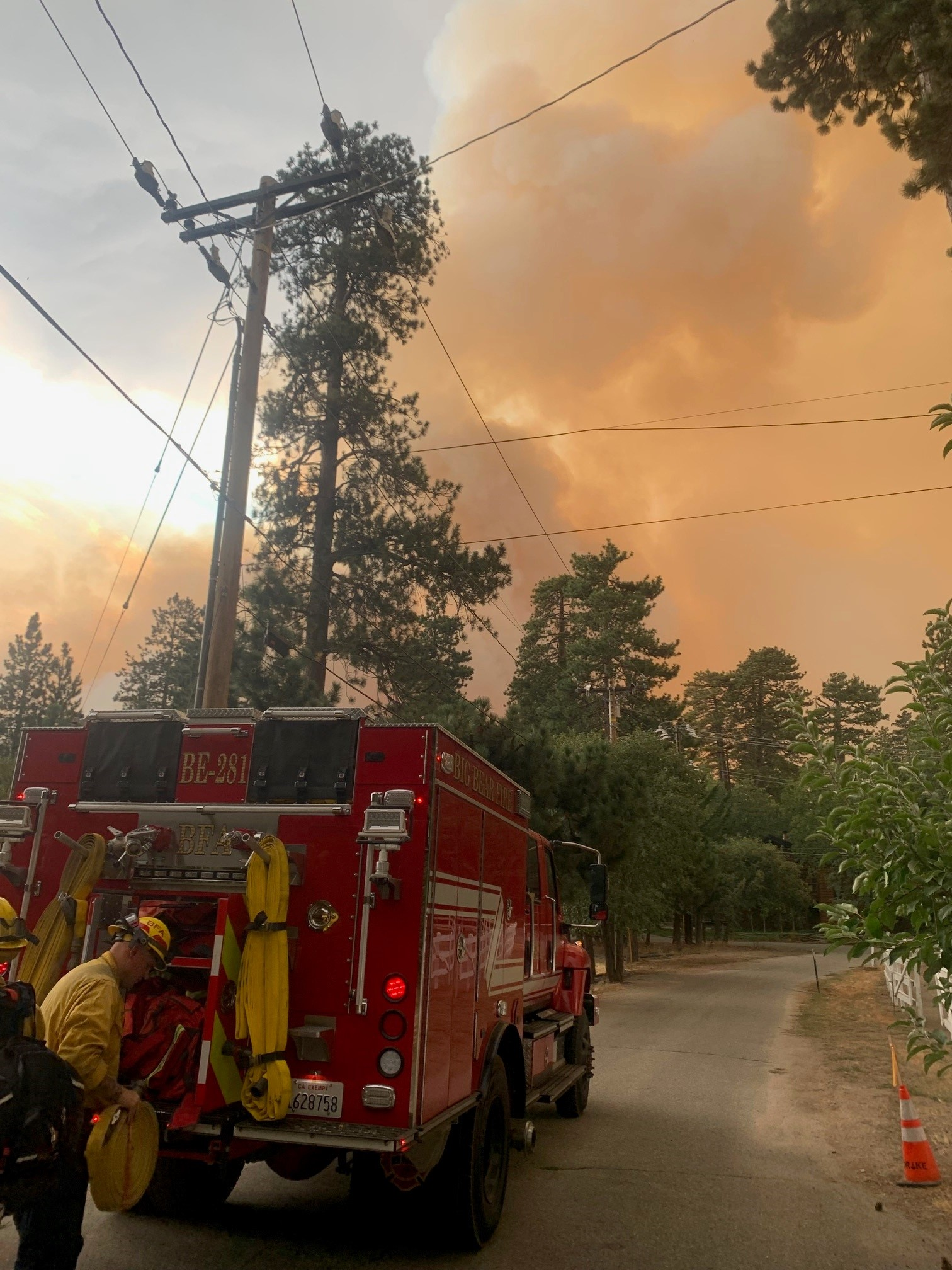
Big Bear Fire has been assigned to contribute with equipment and personnel in the Running Springs area.” – Fire Chief Jeff Willis (9/7/2024 2030 PT)
US National Weather Service – San Diego California | Pyrocumulus clouds can form when very hot surface conditions exist, like extremely hot/large fires or volcanic eruptions! These photos, courtesy of @FirePhotoGirl, are of pyrocumulus clouds that developed earlier today over the Line Fire in San Bernardino County, near Highland, CA. These clouds can create very dangerous conditions for firefighters, producing gusty winds, lightning, and even rain. Up through 630PM, we recorded over 3700 lightning strikes inside the clouds directly over the Line Fire, with over 280 ground strikes!
NWS IMET Operations | IMET deployed earlier today.
Photo Credit: NWS IMET Operations

CURRENT STATUS
Size Up | Extreme fire behavior with backing, flanking, short-range spotting, and short uphill runs. 7,122 acres. 0% containment status.
Evacuation Orders & Warnings | https://inciweb.wildfire.gov/incident-information/cabdf-line?fbclid=IwY2xjawFKBw1leHRuA2FlbQIxMAABHdSyPa-qE6YAvJs7yRJw8VrplAm6XUmU3OYt3FDKMts7vZ74ofKbWR8Ceg_aem_R3hF1Ogr-d6fjmEvd3cfRg (Source: Inciweb) and can be found on CAL FIRE’s website: https://www.fire.ca.gov/incidents/2024/9/5/line-fire?fbclid=IwY2xjawFKCjFleHRuA2FlbQIxMAABHTZTRLkkQ7nLSDh5fDtOZMm0gem6ZhdobbTTGYEVXB6lc_Wwc6rspvvTJw_aem_uDjtQpUyxHavWYrD0sJVuw
The Walmart Shopping Center / Highland Avenue Plaza in the 4000 block of E. Highland has now been evacuated due to the fire. (Source: Media, 9/7/2024 2036 PT)
Evacuee Resources | The Telephone Emergency Notification System (TENS) sends Important Messages and Emergency Alert Notifications from San Bernardino County Emergency Management. Visit http://readysb.com to sign up for this alert system on impending dangers.
Evacuation Shelter | Immanuel Baptist Church, 28335 Baseline Street, Highland, CA
Animal Shelter | Devore Animal Shelter – 19777 Shelter Way, Devore, CA. 909-386-9820 (Business Hours) or 800-472-9820 (after hours).
Threats | 8,733 structures threatened, including single and multi-family homes, commercial buildings, and other minor structures.
Injuries | Three have been confirmed to fire personnel and civilians.
THROUGH THE EYES OF SOCIAL MEDIA
“”Nighttime operations are well underway on the #LineFire with two Chinooks and a couple helicopters working on the Highland side of the fire.” – Big Bear Community Facebook Page (9/7/2024 2036 PT)
“Nighttime operations are well underway on the #LineFire with two Chinooks and a couple helicopters working on the Highland side of the fire.” – Local Fire Chaser (9/7/2024 2025 PT)
“The Line fire has destroyed everything in its path the last few days, especially today. This was my main drive up and down the mountain. I’m devastated about this one.” – Local area Photographer (9/7/2024 1931 PT)
“We made it safely to friends in Lake Arrowhead. Pray for all the first responders and that the rain keeps coming!” – Local Resident (9/7/2024 1910 PT)
“This is extreme fire behavior on the #LineFire on HWY 330 going towards Running Springs.” – Local Fire Chaser (9/7/2024 1703 PT)
“As of 2PM, it’s traveling in multiple directions toward East Highland homes and into the National Forest due to spotting and wind gusts blowing down the canyon. Mandatory evacuations are in place from Calle Del Rio (Highland) to Highway 38 including Greenspot Road north, as well as all underdeveloped land east of Highway 330 to Summer Trail Place and north of Highland Ave.” – Community Facebook Page (9/7/2024 1400 PT)
“Farewell house. Praying for the firefighters and all of my fellow residents.” – Local Area Resident (9/7/2024 1354 PT)
“The Line Fire continues to burn in the foothills of the San Bernardino Mountains, forcing evacuations for neighborhoods in Highland, CA. Extreme temperatures are making matters worse, with highs expected near 110° this afternoon.” – WeatherNation (9/7/2024 1336 PT)
“An eerie scene here of smoke from the #LineFire flowing over the mountains just north of #Highland. It’s burned over 3,800 acres and is still 0% contained. Evacuation orders now for Calle Del Rio east to Highway 38 and Greenspot Road north to the foothills.” – Local News Media (9/7/2024 1152 PT)
“Thank you to all the agencies for protecting our City! Stay safe.” – Local area resident (9/7/2024 1118 PT)
“Whoah! Line fire Burned some acreage overnight seeing flames coming over the dam this morning is pretty crazy.” – Local Fire Chaser (9/7/2024 0742 PT)
SOURCES
CAL FIRE, USFS, San Bernardino County, San Bernardino PD, Inciweb, LAFD, and Social Media.
(c) 2024 NW Fire Blog

Prayers to everyone up the Mountain. Thanks to USFS & all responders. Stay safe.
LikeLike