

MADRE FIRE – JULY 2025
JULY 3, 2025, THURSDAY
@ 1625 HOURS PDT

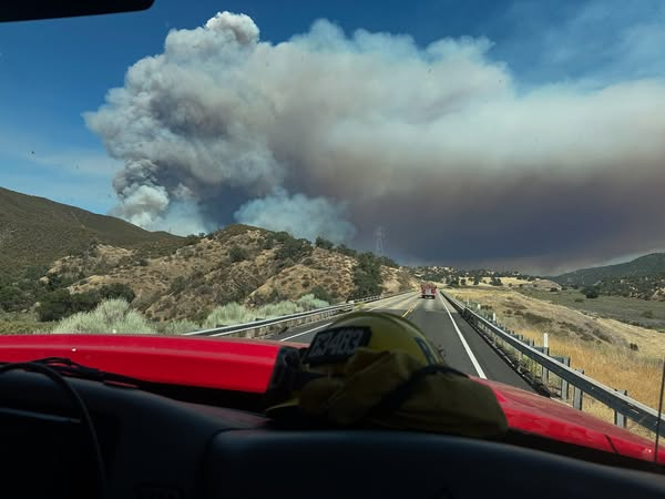
The fire has now burned up to 52,593, almost doubling in size within 24 hours. Fire personnel and resources are starting to gain control of the fire, which has now been reported to have a 5% containment status.
It is located about 25 miles north of Huasna. California.
Fire behavior continues to rage as being extreme, with long-range spotting and uphill runs
EVACUATIONS REMAIN IN EFFECT. Updates –> CAL FIRE https://www.fire.ca.gov/incidents/2025/7/2/madre-fire
There are 303 total personnel with four (4) helicopters, 39 engines, four (4) water tenders, two (2) crews, and 60 other types of resources assigned.
Incident Cooperators include the Los Padres National Forest (USFS), CAL Fire SLO, and the Bureau of Land Management (BLM).
CTD: 2 Million Dollars.
JULY 2, 2025, WEDNESDAY
@ 2345 HOURS PDT
The fire has now burned about 35,531 acres in the San Luis Obispo County area, per CAL FIRE’s website. The fire broke out at 1307 hours PDT this afternoon, where the fire is located on Hwy 166 in the New Cuyama area. Unified Command is in effect with the Los Padres National Forest, CAL FIRE SLO, and the Bureau of Land Management (BLM). There is no IMT assigned as of yet. No cause has been released by Officials, and they state it is under investigation.
EVACUATION ORDERS ARE STILL IN EFFECT.
- Evacuation Order Updates | CAL FIRE https://www.fire.ca.gov/incidents/2025/7/2/madre-fire
@ 2320 HOURS PDT
Photo Credit | San Luis Obispo Sheriff’s Office

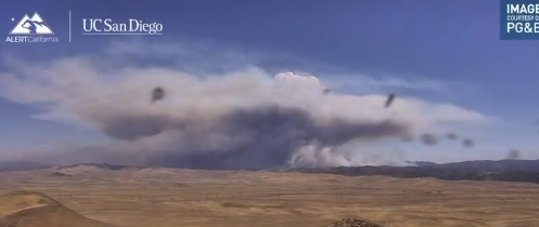
The MADRE FIRE is burning near Hwy 166 in Santa Maria (San Luis Obispo and San Bernardino Counties), California (USA). It is now said to be burning east of the town on the border of Santa Barbara and SLO Counties.
The fire has burned a total of 10,000-plus acres and it is only growing larger, after it broke out just after 1300 hours this afternoon. Quickly, the fire behavior became extreme, burning everything in its path to a massive 9,000 acres in a short amount of time.
EVACUATIONS ARE IN EFFECT.
- SHELTER — Cal Valley CSD. 13080 Soda Lake Rd, Santa Margarita.
- EVACUATION UPDATES —https://www.emergencyslo.org/…/wireless-emergency…
Photo Credit | ALERT California / UC San Diego
Units include:
CAL FIRE – SLO | Strike Team 9340C. They were on another wildfire incident but diverted this afternoon to this [FIRE].
SANTA MARIA FIRE | Local 2020 is on standby.
Resources include: Intel 24, CAL FIRE Type 3 Air Tanker (loading from Tanker base 27 miles from fire),
Incident Cooperators include: CAL FIRE SLO, US Forest Service – Los Padres National Forest, and Bureau of Land Management (Unified Command). San Luis Obispo County Sheriff’s Office, Kern County FD, Senator Monique Limon.
FIRE FACTS VIA CAL FIRE – SISKIYOU UNIT
Yesterday’s (Tuesday, July 1st) lightning storm produced over 3,588 lightning strikes, including 1732 in the State Responsibility Area. All fires in the State Responsibility Area are contained and in patrol status except for the new fire near Big Springs, held at 2.8 acres with forward spread stopped, and a line around the fire. Crews will focus on suppression repair, addressing areas damaged by the fire, as well as mop-up operations. Backhaul of all excess equipment on the line will also continue. Efforts remain dedicated to securing the areas and ensuring no further threats. Details on each fire are provided below.
- Perch: 24.4 acres, 100% Containment
- Harry: 5.35 acres, 100% Containment
- Bridge: 0.1 acres 100% Containment
- Iron: 0.1 acres, 100% Containment
- Cattle: 0.01 acres, 100% Containment
- Rider: 0.01 acres, 100% Containment
- Houston: 0.01 acres, 100% Containment
- Lime: 0.01 acres, 100% Containment
- Fowlers: 0.05 acres, Containment
- Meadow: 0.02 acres, Containment
- Big: 0.01 acres, Containment
- Machado 2.8 acres, 5% Containment
Photo Credit | CAL FIRE SLO
THROUGH THE EYES OF SOCIAL MEDIA
The area of the Carrizo Plain is getting burned by the [FIRE], which has little to no burn history. This is a sensitive and rare habitat full of species found nowhere in the world. – Climate Scientist
The [FIRE] can be seen from the KBAK//KBFX rooftop looking to the southwest with a pyrocumulus cloud and creating its own fire weather. – Local News Station
In 1999, there was an 11,000+ acre fire called the SPANISH RANCH FIRE that burned to the west and on the north side of Hwy 166 that killed 4 CDF Firefighters. That blaze about a week, but most of its acreage was consumed in about four (4) days. – Social Media commenter
One of these fires is an example of one that they should let burn. Backcountry lightning fires have been going on forever until we started putting them out. They’re putting out a fire that needs to happen now, when conditions are favorable to keep it low intensity. – YouTuber
(c) 2025 NW FIRE BLOG
