

Yes, we know we are a little late to the game but I [have] been fighting the flu and hoping it is just a bit at the tail end. Now, that I am upright, thought I’d share what has been spreading like wildfire all over Social Media and is on the fire ground in AZ and CA – not a pretty sight.

Our Thoughts and Prayers are there for those are involved in this powerful wind-driven firestorm of 2016.
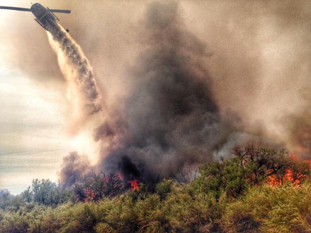
FIRE SUMMARY
The fire started on Wednesday, April 6, 2016, around 0500 hours on two specific sites on the Arizona and California borders on the Colorado River Ranger District.

NOTE: Generally where there are two separate fire names, it is because they have started one name and it is changed over time to reflect a more accurate location. This fire is listed to be two different locations on both the AZ and on the CA sides. We are unsure if there were two different origins, so we’ll that up to the Fire investigators to figure that one out, but for the purpose of this post – we will refer to the #TopockFire as on the #AZFire side and the #PirateFire on the #CAFire side.
The fire is known by two names, #TopockFire on the Arizona side, is approximately two (2) miles West of Topock and Golden Shores, Arizona.
The #PirateFire is on the California side, about ten (10) miles SSE of Needles, California.

The cause is unknown, but it is listed as an active investigation. No updates from that investigation have been released.
COMMAND
Due to the fire being on both sides of the Arizona-California borders, Command is in an Unified Command Status.

PERSONNEL
There are about 165 personnel assigned to this incident, including Mutual Aid from the following:
- Bureau of Land Management
- Fish and Wildlife Service
- Arizona Dept of Transportation
- AZ Dept of Forestry
- BNSF Railroad
- Buckskin Fire Department
- Bullhead Fire Department
- CAL Transportation
- California Highway Patrol

- City of Needles
- Fort Mohave Fire Department
- Golden Shores Fire Department
- Kingman Fire Department
- Mohave Valley Fire Department
- PG & E
- San Bernardino County Fire Department
- San Bernardino County Probation
- San Bernardino Sheriff’s Office
- SW Gas Corporation
We are still trying to find out what type of crews, equipment and apparatus is on-scene but so far, we haven’t found that jackpot yet. We will put out more updates as information is received.
FIRE STATUS
DAMAGE ASSESSMENTS
- 2200 total acres (both AZ-CA) as of 4/7/2016
- Pirates Cove Resort in California suffered some about 10% roof damage due to firebrands burning the thatch room.
EVACUATIONS
- Evacuations of Park Moabi Mobile Home Park residents and Pirates Cove Resort employees and Campers occurred on 4/6/2016.
- Evacuations have been lifted on 4/7/2016 but employees and Campers are only allowed to recover their possessions with an escort.
- Park residents evacuation orders have been lifted and appears there are no restrictions returning to their homes.
CONTAINMENT STATUS
- 40% containment status.
WEATHER CONDITIONS
Windy conditions have arrived and firefighters have been able to establish containment lines. So far, they are reporting that they are holding.
Golden Shores, Arizona is reporting a warm temp of 89-degrees with 15% percipitation, 9% humidity and winds at 6-mph.
CLOSURES
Roads
- Route 66 from Golden Shores to I-40.
- BLM using roadway for equipment and staging areas.
- Reports on Facebook are not accurate.
(c) 2016 The #NWFireBlog
Disclaimer: The Photography in this post is not our own and we do not lay rights or claims on them. We have given the Photo Credit to the best of our knowledge and all rights of those of the Photographer as listed. – Editor.
