
Thank you for following our Blog posts about adverse weather conditions in Washington State. All information is gleaned from verified sources from government, fire departments, law enforcement, emergency management and other public information.
We will try to list the source where the information is bein received from in a Sit Rep format gleaned from all Social Media channels being broadcasted from.
***
Weather Fact |Our soggy weather has been sent with a red bow on top all the way from the tropical (U.S.) State of Hawaii. – Source: NWS Seattle
***
KING COUNTY
AUBURN
Road Closures
SE Lake Holm Road between 130th Ave SE to Auburn Black Diamond Rd | Water over roadway | 2-6 0338 PST
BLACK DIAMOND
Road Closures
Enumclaw Franklin Rd SE between Franklin Ridge gravel pit and SE Green River Gorge Road | Damaged roadway | 2/7/2020 1205 PST
Sandbag Distribution Center
King County Roads Facility | 20827 SE Auburn Black Diamond Rd. Open 24/7. Empty sandbags and sand provided by County. Self-service. Max 25 sandbags per vehicle. Bring your own shovel.
***
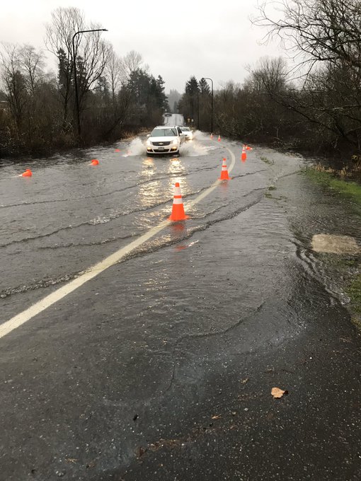
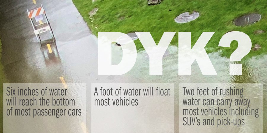
Water Facts | 6″ of water will reach the bottom of most passenger cars – Weather Alert
***
CARNATION
Road Closures
310th Ave NE between NE Carnation Farms Rd and SR 203 (including NE 60th St) | Water over roadway | 2-7 1355 PST
NE 100th St between W Snoqualmie Valley Rd NE and NE Carnation Farm Rd | Water over roadway | 2-6 1024 PST
NE Tolt Hill Rd between SR 203 and W Snoqualmie River Rd NE | Water over roadway | 2-6 0838 PST
W Snoqualmie River Rd SE between #1550 x NE Tolt Hill Rd | Water over roadway | 2-1745 PST
NE Tolt Hill Rd between SR 203 and W Snoqualmie River Rd NE | Water over roadway | 2-6 0838 PST
Sandbag Distribution Center
City of Carnation Public Works | 33100 NE 45th St. | Hours: Weekdays from 0800 – 1630 PST. Empty bags and sand provided.
***
Water Fact | A foot of water will float most vehicles. – Weather Alert
***
BELLEVUE
Road Closures
EB lanes on Coal Creek Pkwy from 124th Ave SE to Factoria Blvd | Downed trees on power lines | 2-7 2309 PST | Source & Photo Credit: City of Bellevue Transportation
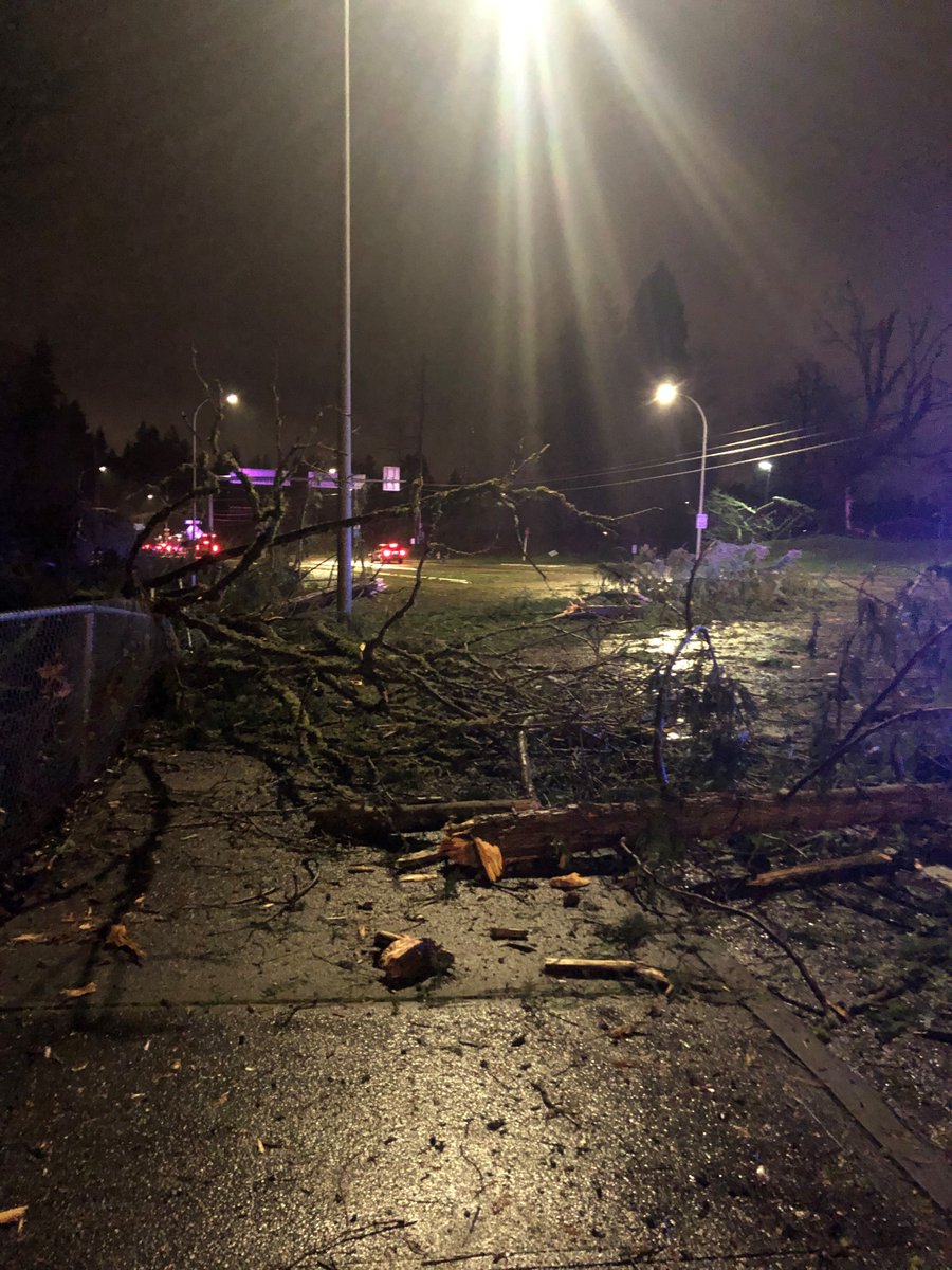
SE Newport Way from SE 42nd Pl to 133rd Ave SE | Downed trees on power lines | 2-7 2309 PST
Intersection of 134th Ave SE x SE 42nd St | Downed trees on power lines | 2-7 2309 PST
SB Coal Creek Parkway. Both lanes. | Downed tree and power lines over roadway | 2-7 2037 PST
Open Roadways
SE 7th Place, east of Lake Hills Connector | OPEN | was closed 2-5 due to flooding | 2-7 0630 PST
DUVALL
Flooding Images
The rising of the river is being captured by many photographers as records are being broken all over the State. Here is a video clip showing extreme flooding. | Video Credit: City of Duvall
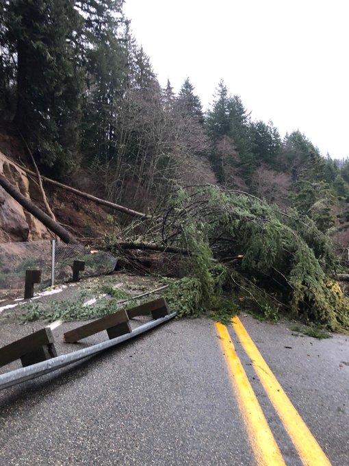
SR 410 X MP 38
(BETWEEN ENUMCLAW & GREENWATER)
Road Closures
A major landslide shutdown this busy thoroughfare. | Photo Credit: WSP Sgt. Zimmerman & Courtesy of WSP Trooper / PIO Rick Johnson
FALL CITY
Road Closures
SE David Powell Rd x Preston Fall City Rd SE | Landslide | 2-7 0015 PST
316th Av SE x SE 28th St between SE 24th St and 321st Ave SE | Water over the roadway | 2-6 1115 PST
SE 308th St between SR 202 x SE 31st St | Water over roadway | 2-6 1115 PST
Neal Road SE x SR 203 | Water over roadway | 2-6 0338 PST
Sandbag Distribution Center
King County Roads Facility | 33719 SE 44th Place | Open 24/7. Empty bags and sand provided by County. Self-service. 25 max bags per vehicle. Bring your own shovel.
Water Fact | 2 Feet of rushing water can carry away most vehicles including SUVs and Trucks. – Weather Alert
MAPLE VALLEY
Road Closures
Dorre Don Way SE x 230th Ave SE | Water over raodway | 2-7 1315 PST
Maxwell Rd SE between SE Lake Francis and 220th Ave SE | Erosion of roadway | 2-7 1117 PST
Lower Dorre Don Way SE between Upper Dorre Don Way SE to Dorre Don Way SE (the loop) | 2-7 0620 PST
NORTH BEND
Road Closures
Cedar Falls Rd SE x SE 177th St | Water over roadway | 2-7-2020 1050 PST
428th Ave SE between SE Reinig Rd and SE Ernies Grove Rd | 2/6/2020 1215 PST
Sandbag Distribution Center
City of North Bend City Hall | 920 SE Cedar Falls Way. | Hours: Monday-Thursday 0830 – 1600 PST, Friday 0830 – 1200 PST. | Empty sandbags and sand provided by City. Self-service. Shovels available. Check in City Hall before bagging. Bags available after hours when the EOC is open due to flooding.
PACIFIC
Road Closures
W Valley Hwy S between Ellingson Rd x 3rd Ave SW | Water over roadway | 2-6 1600 PST
Sandbag Distribution Center
City of Pacific | 130 3rd Ave SE. (Across from Police Station) | Open 24/7. Empty sandbags and sand available. Self-service. 25 max bags per vehicle. Bring your own shovel.
PALMER
Road Closures
SE 309th St between 335 Ave SE to W to end of road | Landslide | 2-7 1852 PST
REDMOND
Road Closures
NE 124th St between W Snoqualmie Valley Rd NE x SR 203 | Water over roadway | 2-6 0930 PST
204th Pl NE between NE 67th St x SR 202 | Water over roadway | 2-6 0845 PST
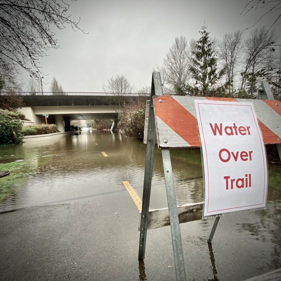
Park / Trail Closures
Sammamish River Trail at Leary Way | Standing water
Farrel-McWhirter Park | some interior trails closed
Redmond West Wetlands
Bear Creek Trail between Redmond Way and Avondale way
Evan’s Creek Trail from Perrigo Park South to the raised boardwalk area | Water over boardwalk
Bear Creek Bridge on the Puget Sound Energy Trail
Water Safety
The rain is continuing to fall and we want to remind you to avoid driving, walking or riding through standing water. | Source / Photo Credit: City of Redmond
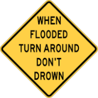
Turnaround, Don’t Drown
The Redmond Police Department would like to remind drivers to never drive around any road closure signs present on flooded roadways. | Photo Credit: RPD. Photo taken on February 5th of NE 95th St, east of Willows Road.
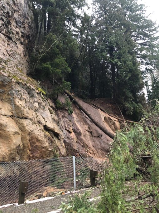
Landslide Awareness
Fact Sheet: Recognize Landslide Warning Signs
- Changes in your landscape such as patterns of storm-water drainage on slopes (especially the places where runoff water converges) land movement, small slides, flows, or progressively leaning trees.
- Doors or windows stick or jam for the first time.
- New cracks appear in plaster, tile, brick, or foundations.
- Outside walls, walks, or stairs begin pulling away from the building.
- Slowly developing, widening cracks appear on the ground or on paved areas such as streets or driveways.
- Underground utility lines break.
- Bulging ground appears at the base of a slope.
- Water breaks through the ground surface in new locations.
- Fences, retaining walls, utility poles, or trees tilt or move.
- A faint rumbling sound that increases in volume is noticeable as the landslide nears.
- Unusual sounds, such as trees cracking or boulders knocking together, might indicate moving debris.
- Collapsed pavement, mud, fallen rocks, and other indications of possible debris flow can be seen when driving (embankments along roadsides are particularly susceptible to landslides).
After the Landslide
- Go to a designated public shelter if you have been told to evacuate or you feel it is unsafe to remain in your home.
- Stay away from the slide area. There may be danger of additional slides.
- Listen to local radio or television stations for the latest emergency information.
- Watch for flooding, which may occur after a landslide or debris flow.
- Check for injured and trapped persons near the slide, without entering the direct slide area. Direct rescuers to their locations.
- Check the building foundation, chimney, and surrounding land for damage. Damage to foundations, chimneys, or surrounding land may help you assess the safety of the area.
https://www.fema.gov/news-release/2017/10/17/4339/fact-sheet-recognize-landslide-warning-signs | Source & Photo Credit: FEMA via City of Redmond / Photo Courtesy
RENTON
Road Closures
SE Jones Rd between #18631 x SR 169 | Landslide | 2-6 2024 PST
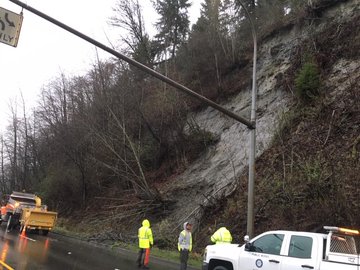
Landslides in Fire / Disaster Images
(L) This photo was taken on February 5, 2020, of a landslide on the WB side of Maple Valley Hwy and across 1.5 lanes. It would take fire crews and mutual approximately 3-4 hours to remove it. Mud and debris impacted drivers on the highway and forcing officials to close it protecting the motoring public. | Photo Credit: Renton Fire / RFA PIO
Sandbag Distribution Center
King County Roads Facility | 155 Monroe Ave NE | Open 24/7. Empty sandbags and sand provided. Self-service. 25 max per vehicle. Bring your own shovel.
SEATLLE
Sandbag Distribution Centers
Delridge Community Center | 4501 Delridge Way SW, 98106. | Filled sandbags. Self-service. 25 max per household or business.
Helene Madison Pool | 13401 Meridian N, 98133 | Same messaging.
South Park Neighborhood | 731 S Sullivan, 98108 | Same messaging.
Meadowbrook Community Center | 10517 35th Ave NE, 98125 | Same messaging.
SKYKOMISH
Sandbag Distribution Center
King County Roads Facility | 74212 Old Cascade Hwy | Open 24/7 | Self-servce. 25 max per vehicle. Bring your own shovel.
SNOQUALMIE
Road Closures
SE Reinig Rd from the City of Snoqualmie limits to 396th Dr SE | 2-6 1115 PST
W Snoqualmie Valley Rd NE at NE 124 | 2-7 2110 PST

Restricted Roadways
356th Dr SE, N of #4030 | 1 lane closed due to road failure. 1 lane open and alternating traffic. Expet long delays. | 2-6 2142 PST
Sandbag Distribution Center
City of Snoqualmie. | 38190 SE Mill Pond Rd. | Weekdays from 0700 – 1500 PST | Must call Public Works at 425-831-4919 for an apoointment to pick-up sand and bags. During flooding, call the EOC at 425-888-5911 for sandbags.
SNOQUALMIE PASS
Road Closures
Weather Forecast – Snow
Reports of up to 14″ of new snow on the Pass from 2300 hours on Thursday and Friday were reported by law enforcement. Chain enforcement was scheduled at 1600 hours to midnight on eastbound on I-90 over the pass. | Source: WSP PIO / Trooper Rick Johnson
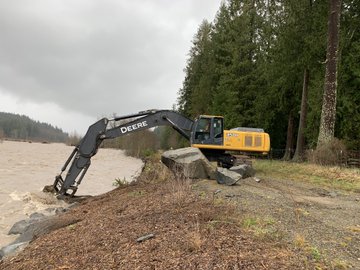
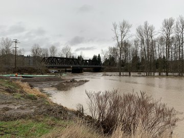
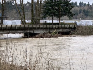
SNOQUALMIE FALLS
Flooding Impacts
The Falls are yet again overflowing at a high rate of speed and splash. This image shows the magnitude of flooding we are experiencing and showing us its dangers of the rate of speed and splash. | Source / Photo Credit: City of Snoqualmie
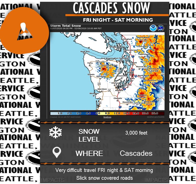
CASCADES
Weather Forecast – Snow
This also includes Snoqualmie Pass. Snow levels are expected to drop by early Saturday morning. 12-18″ expected are possible. | Source & Photo Credit: NWS Seattle
PIERCE COUNTY
PUYALLUP
Road Closures
PUYALLUP RIVER | Roads, Surface Water and Emergency Management crews and personnel were busy with damage assessments from flooding in various areas. This was conducted across the whole County. Currently, there are on-going repairs in progress on the the Puyallup River Levy above Orting within two hours after the discovery of the damage.
One of Pierce County’s Executives, Bruce Dammeier was out with crews for the full day observing damage assessments and excellent / tireless efforts by crews to fix roadways and other major maintenance. | Photo Credit: Pierce Co. Government. Source: PC Exec Bruce Dammeier.
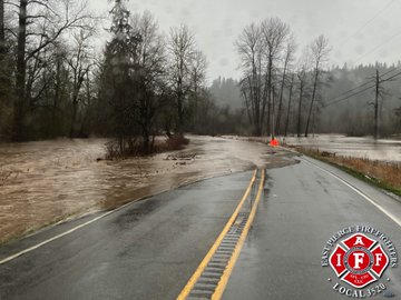
EAST PIERCE COUNTY
Damage Assessments
SR 162 | Images show extensive impacts on SR 162. Photo taken on Thursday, February 6, 2020. | Source / Photo Credit: East Pierce Firefighters, IAFF Local 3520
RESOURCES
Road Service Helpline
KING COUNTY | 206-477-8100, 800-527-627 | King County Road Services Helpline – 24/7 . Website: https://kingcounty.gov/depts/local-services/roads/24×7-helpline.aspx Sign-up for road alerts at https://kingcounty.gov/depts/local-services/roads/road-alert.aspx
Life-Threatening Medical / Fire Hazard or Criminal Act in Progress/Occurred
9-1-1 | Emergencies only for FIRE, EMS, POLICE.
PUBLIC SERVICE ANNOUNCEMENTS
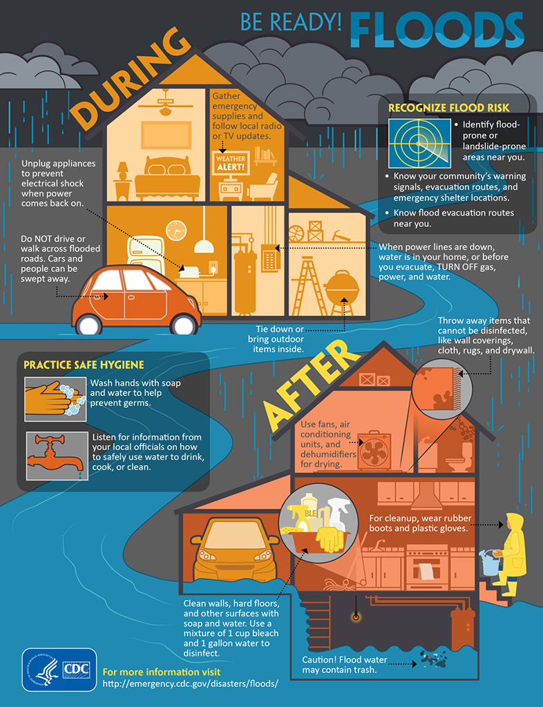
Water Safety
As the rain continues, follow safe guidelines: do NOT walk or drive across flooded roads; gather emergency supplies and follow local updates; use flashlights instead of candles if you lose power. | Source: King County Public Health
THROUGH THE EYES OF SOCIAL MEDIA – EYEWITNESS ACCOUNTS
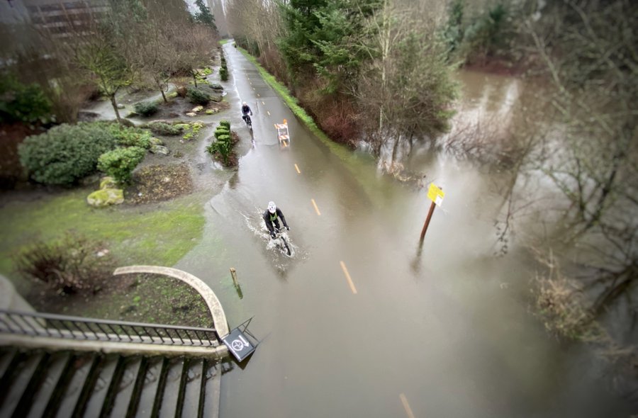
Issaquah Creek
“Cars are submerged in flood waters in Issaquah as Issaquah Creek continues to rise up quickly. Current was reported as being very strong. ” | News Media on Thursday, February 6, 2020.
(c) 2020 NW Fire Blog – Update 2 – 2/7/2020 2315 PST
