AUGUST COMPLEX | HUMBOLDT and MENDOCINO Counties

SIT REP 1 | September 19, 2020

INCIDENT SUMMARY:
The AUGUST COMPLEX is made up of several wildfires include the DOE FIRE that is burning on the Mendocino National Forest in counties of Humboldt and Mendocino.
The incident started on August 16, 2020 in the Mendocino National Park.
“This is the State’s largest wildfire. Ever.” – CA Fire Foundation
UNIFIED COMMAND:
Command is Unified Command with Mendocino National Forest, CAL FIRE Mendocino Unit and the Humboldt Del Norte Unit.
Almost a million acres or more accurately 832,891 acres have been destroyed from this lightning-caused wildfire. Fire crews have reached a 30% containment status.

RESOURCES:
There are 2,149 total personnel assigned to the incident along with 52 crews that represent from 4 Fire Agencies. Additionally, there are 17 helicopters, 195 engines, 72 dozers and 49 water tenders, which is so unheard of in the past but more common in today’s world.
Incident Cooperators | Humboldt County OES, Yolo-Solano AQMD, South Metro Fire Rescue, Shasta-Trinity NF, Mendocino NF, CA Fire Foundation, Six Rivers NF, County of Sonoma, Red Cross, Swinteron Renewable, Sarasota County FD, San Lorenzo Valley Water District, BLM California.
HEARD FROM THE FIRE GROUND
Firefighters have been for the last month fighting multiple lightning caused wildfires, with this one being the biggest in the State of California. Ever. Here are the eyewitness accounts from the fire ground first hand through photos and despictions.
Photo Credit | CAL FIRE AEU
After fighting fires for the past 24 days, AEU Strike Team 9272C is leaving the LNU Lightning Complex and now heading to their 4th fire assignment since August 18th. They took a moment to recognize 9-11 heroes today before their next assignment.
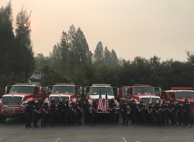
Photo Credit | SCG Emergency Services
Sarasota County Fire Department Wildfire Mitigation Specialist David Cavanaugh is temporarily assigned to the August Complex fire near Stonyford, California. Thank you David for all your hard work keeping others safe!
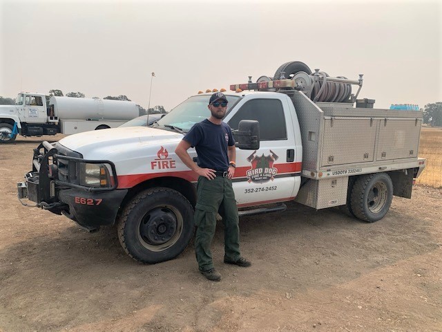
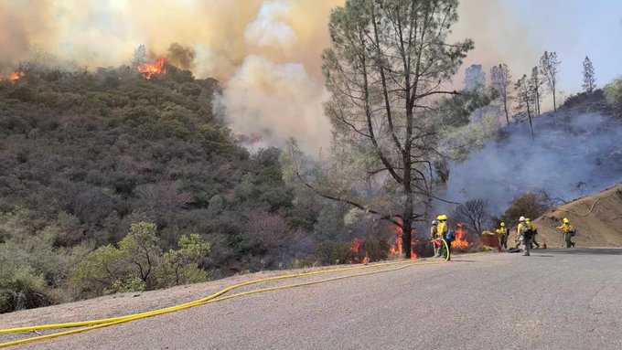
Photo Credit | Flower Mound MD
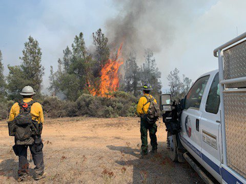
On today’s 24 hour shift at the #AugustComplex West Zone, Strike Team 139 has been assisting other hand crews with back burning operations. These operations use fire to remove fuels between the containment line and the active fire.
Photo Credit | South Metro Fire Rescue
BRE41’s wildland team is working the night shift on the #AugustComplex fire in #California under the Redding Command Team. Firefighters are setting up sprinkler systems for structure protection. This system is setup in a nearby creek to protect 10 homes. Briefings held virtually.
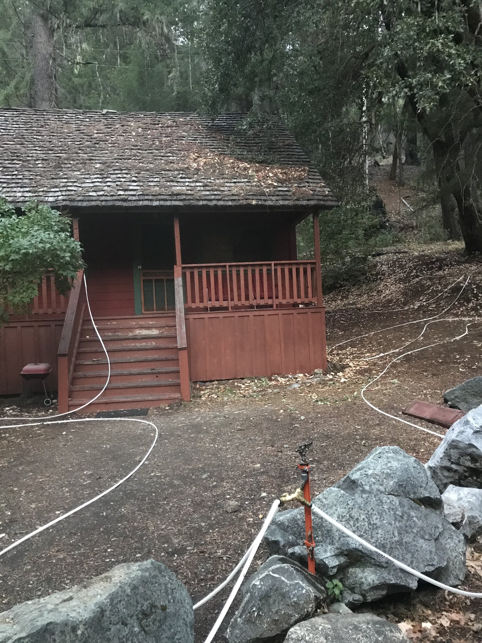
Photo Credit | McKinney Fire (TX)
The MFD crew in California coming off a 24-hour shift on the line at the August Complex Fire. The crew spent the day doing structure protection prep — then shifted to a massive 2 mile firing operation all night. #californiafires #wildfires2020 #TIFMAS
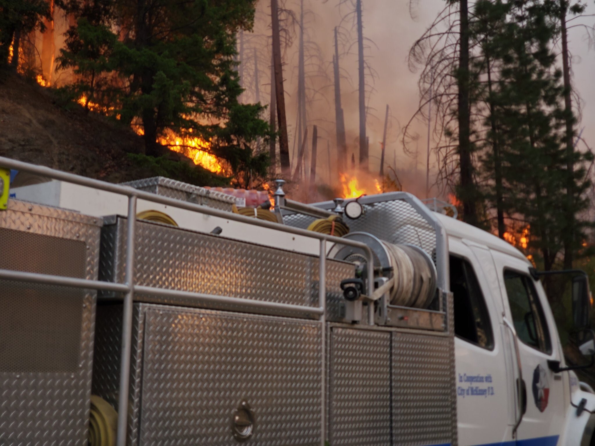
Photo Credit | US Army North #JFLCCCresponds @USArmyNorth (Twitter)
Every single foot of hose must be carried in & placed by hand to help reinforce dozer lines & prepare for burnout operations-14th BEB Soldiers & USFS wildland firefighters are working together to build fire lines, remove fuels & slow the spread of the August Complex fire.
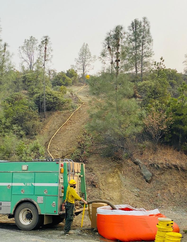
Photo Credit | Fort Worth FD
Strike team #139 which includes 8 of #yourFWFD firefighters continues to work the August complex fire in Northern California. We will update as we get information.


Photo Courtesy | Inciweb
A NWS Burlington IMET is in the Command Post. This wildfire is near Elk Creek, CA.
EVACUATIONS:
- Zone AB: South of the Middle Fork of the Eel River, west of Eden Creek, north of Salt Flat and east of Salt Creek
- Zone AC: East of Brushy Mountain, south of the fire road on Salt Flat, west of Eden Valley and north of Bald Mountain
- Zone E: South of the county line, east of the National Forest boundary, north of Forest Highway 7 and west of the county line near the M2.
“In 2020, there was a total of 3,400,000 acres burned. 25 Souls lost their lives.” – CA Fire Foundaiton
- Zone C: North of the M1, East of the National Forest Boundary, south of Forest Highway 7.
- Zone B: West of Evacuation Zone A, North of Jack Hollow Creek and Thatcher Creek, East of the Middle Fork of the Eel River, South of Green Lambert Canyon through Bentley Basin to the M1 and South of the M1, to include Timber Ridge, and Bentley Ridge, and Hayshed Basin.
- Zone A: West of the county line, south of Anthony Peak and North of Hull Mountain.
- Zone F: East of the National Forest boundary near Garcia Creek, South of Thatcher Creek, west of the County Line and North of the County Line on Hull Mountain.
- Zone H: West of the National Forest Boundary, North of Thomas Creek and the Eel River, East of Twin Bridges Creek, South of Bald Mountain
- Zone I: West of Elk Creek, South of Deep Hole Creek, North of the National Forest Boundary.
- Zone J: East of Elk River, north of Deep Hole Creek, east of Eden Valley, south of Thatcher Creek.
- Zone W: West of the Eel River, north of Deep Hole Creek, east of Eden Valley including the entire valley floor, south of Eden Creek.
- Lake County: All areas north of Pack Saddle; west of Lake County line; East of the Lake County line.

EVACUATION WARNINGS:
- Zone S: South of the County Line, East of Bell Springs Rd, North of Bell Springs Creek and West of the North Fork of the Eel River.
- Zone Q: South of the County Line, West and North of the North Fork of the Eel River, North and East of Bald Mountain Road.
- Zone D: South and East of the Eel river, North of Bentley Basin and West of the National Forest Boundary.
- Zone N: North of the Middle Fork of the Eel River including the Eel River Ranger Station and Black Butte Store, West and South of the National Forest Boundary, East of Williams Creek.
- Zone U – South of the County Line, east and north of the East Branch of the South Fork of the Eel River, west of Bell Springs Rd.
- Zone T – South of Bell Springs, east of Bell Springs Rd, north of Iron Peak and Simmerly Rd, west of the Eel River.
- Zone R – West of and south of Mina Rd, south of the North Fork of Eel River, east of the Eel River.
- Zone P – South of the County Line, east of Mina Rd, north of Hulls Valley Rd and west of Hulls Creek.
- Zone O – South of the County Line, east of Hulls Creek, north of Mendocino Pass Rd, and west of Williams Creek
- Zone L: South and West of Mendocino Pass Rd, West of The Middle Fork of the Eel River, north of Eel River Ranch Rd, East of Hill Rd and Short Creek Rd.
- Zone K: West and North of the Middle Fork of the Eel River, East of Redwine Spring, South of Hill Rd and Eel River Ranch Rd.
- Zone X: North of Eden Creek, East of Hearst Willits Rd, South and West of the Eel River.
- Zone G: West of the County Line, North of the Eel River and Van Aresdale Reservoir, East of the Eel River, South of the National Forest Boundary.
- Zone AD: South and west of the Eel River, north of Foster Mountain Road, east of the ridge west of Willits Road
- Zone AE: North of Twin Bridges Creek, east of the Eel River, south of Brushy Creek and west of Brushy Mountain
- Zone AN: South of Highway 162 and the Eel River, west of Salt Creek, north of Brushy Creek and the Eel River, east of Highway 162.
- Zone AQ: North of the Eel River, south and east of Highway 162, west of Redwine Spring.
- Lake County: Pillsbury Ranch Area; North of M-1; South of Lake county line; East of the Lake County line.

ROAD CLOSURES
- Private Driveway to Murphy Creek
- Bell Springs closed to north bound traffic at Lundblade Ranch Road
- Mina Road is closed to north bound traffic at the bridge over the North Fork of the Eel River
- Mendocino Pass Road closed to east bound traffic just east of the Williams Creek Bridge
- Hearst Willits Road at the bridge, closed to east bound traffic
- Hearst Willits Road at the Eel River Bridge
- FH7 at M1 to Eel River
EVACUATION SHELTERS
MENDOCINO COUNTY | Covelo High School, 76280 High School Street, Covelo, CA.
TRINITY COUNTY | Southern Trinity High School, 600 Van Duzen Road.
HUMBOLDT COUNTY | Contact Fire Information line. Phone #707-268-2500 to be connected to available resources.
ANIMAL EVACUATION CENTERS
SMALL ANIMALS | Ukiah Animal Shelter. 298 Plant Road, Ukiah, CA 95482.
SMALL / LARGE ANIMALS | round Valley Rodeo Grounds. 22830 South Airport Road, Covelo, CA.
DAMAGE ASSESSMENTS
There has been 5 structures damaged and 51 destroyed.
(c) 2020 NW Fire Blog – Updated 9/19/2020 1950 PT
