
Thanks for reading our post!

BEAVER FIRE
Medicine Bow NF. Thunder Basin National Grassland -WYOMING. 24 miles Northwest of Walden, COLORADO. Started 6/19/2016 @ 12noon. Managed by Portland NIMO. 232 firefighters. 53% contained. 1 crew. 15 engines. 2 dozers. 4 copters. 4 water tenders.
BERRY FIRE
Grand Teton National Park. 19 Miles NW of Moran, WYOMING. Start 7/25/2016 @ midnight. Cause: Lightning. 34 8 personnel. 13,177 acres. Moderate fire with torching, backing, burnout of downed heavy fuels. Command by the Great Basin IMT 4.
BLACK MOUNTAIN FIRE
10 miles southwest of Swan Valley, IDAHO. Started 8/19/2016 @ 0300 hours. Lightning caused. 13 acres. 80% contained. 12 personnel.
BOX CANYON FIRE
Uinata – Wasatch – Cache National Forest, UTAH. Start July 28th @ 1715 hours. Human caused. 4,181 acres.
BROADWAY FIRE
Medicine Bow NF – Thunder Basin National Grassland) . 30 Miles NNW of Walden / 2 Miles N of WYOMING – COLORADO. Started 8/14/2016 @ 1815 hours. Lightning caused. Managed by Portland Incident Management Team. 322 acres.
BUCK CREEK & SAUL FIRES
Upper Chiwawa River in the Okanogan – Wenatchee National Forest, WASHINGTON STATE. Buck Creek 3,206 acres.
BUFFALO FIRE
Bybee Creek inside Crater National Park, OREGON. Started 7/28/2016 from an unknown cause. 4422 acres.
BYBEE CREEK
WYOMING. 1072 acres.

CARROT FIRE
IDAHO. 343 acres.
CAYUSE MOUNTAIN PASS FIRE
Spokane Indian Reservation) – 8 Miles of Wellpinit, WASHINGTON STATE. The Cayuse Mountain Fire started when the Hart Fire jumped the Spokane River. High winds pushed it to the East side of the river where it is now burning on the Spokane Indian Reservation. The fire on the West side of the river is the Hart Fire. 346 personnel. 18,118 acres.
CEDAR FIRE
Start 7/17/2016 from lightning. Unknown cause. 2 miles northwest of Elk Summit and 11 miles south of the Powell Ranger Station in Nez-Pearce NF in Pearce, IDAHO. 29,322 acres.
CENTRAL FIRE
9 miles west of the Lake developed area and 2 miles south of Hayden Valley, CALIFORNIA. 1043 acres.
CLIFF CREEK FIRE
WYOMING. $32,330 acres.
COPPER KING FIRE
Lolo NF, MONTANA. 8 miles East of Thompson Falls; 1 mile N of Hwy 200. 27,088 acres.ch from the 153rd Airlift Wing, (Wyoming Air National Guard) and the 302nd Airlift Wing, (Colorado Springs, Air Force Reserve) have been deployed to Boise, ID in support of wildland fire operations.
One Convair 580 air tanker group from both British Columbia and Alberta have been deployed to Pocatello and Twin Falls, IDAHO in support of wildland fire operations.
Ciraulo is in Command. 596 acres. 80% contained. In Mop-up operations and securing all lines.
FAWN FIRE
Tatanka Complex. Yellowstone National Park. WYOMING. 2073 acres.
GAP FIRE
Seiad Valley, CALIFORNIA. Started 8/27/2016 @ 1945 hours. 13,020 acres.
HIGH PASS 12.5 FIRE
10 miles west of Junction City, OREGON on private and Bureau of Land Management forest lands protected by the Oregon Department of Forestry’s Western Lane District (Veneta). ODF Incident Management Team 2 (Incident Commander Chris Cline) was dispatched on Friday, August 26, and assumed command of the fire at 8 p.m. that evening. 191 acres.
HOLY FIRE
CALIFORNIA. 155 acres.
MAPLE FIRE
Tatanka Complex – West Yellowstone, WYOMING. – Start 8/8/16 from lightning. 4 miles northeast of the community of West Yellowstone, and 3.5 miles southwest of Mount Holmes Lookout. 36,719 acres.
MOOSE FIRE
IDAHO. 7,963 acres.
NEZ PERCE FIRE
10 miles NE of Butte, MONTANA. Started 8/13/2016 @ 1300 hours by lightning. 344 acres.
PETERSON HOLLOW FIRE
Uinta/Wasatch-Cache NF – 12 Miles NW of Garden City, UTAH. 1207 acres. Started 8/21/2016. 50 acres.
PIONEER FIRE
Boise NF – 8 miles North of Idaho City and NE of Boise, IDAHO. Started 7/18/2016 from an unknown cause. 157,393 acres.
RAIL FIRE
5 Miles West of Unity, OREGON. Start 7/31/2016. Unknown cause. Burning in same area as 2002 Monument Fire. 40,983 acres.
REY FIRE
Santa Barabara County). North of Santa Barbara, CALIFORNIA. 32,606 acres.
ROARING FIRE
IDAHO. 5,439 acres.
ROARING LION FIRE
MONTANA. 8,533 acres.
SOBERANES FIRE
Soberanes Creek, Garrapata State Park, Palo Colorado/Big Sur, & Ventana Wilderness.. Monterey County, CALIFORNIA. 93,714 acres.
SUNCREST FIRE
Leavenworth, WASHINGTON STATE. 465 acres.
TIE FIRE
Caribou-Targhee NF – 10 Miles SW of Victor, IDAHO. 1,031 acres. 450 personnel.
Public Info Meeting -> 9/1/2016 @ 1900 hours. Victor Elementary School, 43 E Center Street, Victor IDAHO.
# # # #
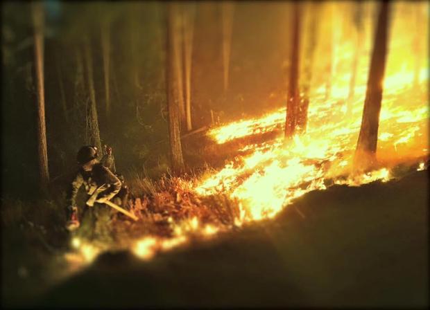
Photography in this post is of the Suncrest Fire in Leavenworth, Washington. (Courtesy of Inciweb)
# # # #
FOLLOW US!
Hope you all enjoyed this post!
You can catch us on our Digital channels on Twitter @nwfireblog or on our Facebook page, The NW Fire Blog.
(c) 2016 The #NWFireBlog
